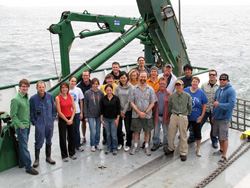
Home Again, Home Again 12:50 a.m. Japan Time Station 32; 37N, 142E Just like that. The CTD is stowed, the last net is aboard. The engines have spooled up and we’re slowly putting the final station behind us, though we’ll initially head northwest to a point half way between Stations 32 and 25. From there, we’ll turn south and follow a course midway between the two innermost sampling lines so that we can make an intermediate line of surface water samples through the ship’s seawater intake. A preliminary accounting of the fruits of our labor so far includes: * More than 1,500 containers ranging from 50 milliliters to 20 liters filled from more than 300 logged sampling events, plus filters of samples as large as 1,000 liters * More than 3,000 liters of water samples weighing more than 3 metric tons that will be shipped to labs around the world after the ship returns to Hawaii * More than 100 tows resulting in about 50 pounds of biological samples (though there is still quite a bit of water in these samples yet) All that, and only three sample containers left unfilled. Not bad for two weeks worth of work. But the real work begins after tomorrow, after everyone has gone their separate ways to wait for their individual shipments of bottles, vials, and bags. Over the coming months 16 labs in seven countries will analyze samples for a laundry list of isotopes that includes cesium-134 and -137; strontium-90; iodine-129; tritium; uranium-236; plutonium-239 and -240; rutherium-103 and -106; radium-223, -224, -228, and -226; and neptunium-237. And that will take time. Many of the instruments used to conduct these tests are extremely sensitive, but the amounts to be detected are extremely small—individual tests could require weeks and entire sample collections many months to complete. Some of the facilities required are highly specialized (one is deep underground to eliminate as much background interference as possible) and scheduling time on them will be a logistical challenge. A few of the methods used to measure trace amounts of some substances have also fallen out of practice as several of the isotopes themselves have faded from the environment after Chernobyl or the cessation of atmospheric nuclear weapons testing. Old techniques will have to be re-learned and some adapted to analyzing seawater or prepared biological samples. That is not to say the scientists feel they have the luxury of time in which to carry out their work. There is still a sense of urgency that this work needs to get done as soon as possible. Plans are already underway for submitting results analysis to the appropriate journals (a rough draft showing preliminary data is already circulating around the ship) and for a meeting of collaborating team members later this winter. It’s often difficult to balance between care and haste, but it is possible. And with the attention to detail that this group has already shown it has, I have few doubts they’ll succeed. There is one other member of this team that has not appeared much in these updates, but without whom we would have been left standing at the dock (literally): the crew of the R/V Ka’imikai-O-Kanaloa. This ship has been a professional, smooth-running base from which to work these past two weeks and the crew bent over backwards to cross half the Pacific at a moment’s notice to make this trip possible. They are: Capt. Clary Gutzeit, Chief Mate John Gall, Second Mate Gary Ramos, Able Seaman George Longshore, Able Seaman Mike Hodge, Able Seaman Rick Hawks, Chief Engineer Robert Tombari, First Assistant Engineer John Carlin, Second Assistant Engineer Dirk Johanson, Third Assistant Engineer John Phillips, Oiler Omar Sherrer, Chief Steward John Grabenhorst, and Assistant Steward Robert Alvarez. In addition, we had two technicians from the University of Hawaii’s Ocean Technology Group who worked around the clock regardless of weather to make sure we were able to get the samples we needed. They are Justin Smith and Paul Balch. To the entire group, thank you and have a safe trip home.
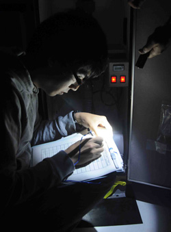
Getting the Story 3:45 a.m. Japan Time Station 29; 36.5N, 142E We haven’t had much news out here on the ship the past two weeks other than our twice-daily satellite email uplinks. My wife, however, just sent me something that makes me a little sad. She said that when she tells people where I am one of the most common reactions has been amazement at how quickly the accident at Fukushima and its aftermath have faded from the news. Of course, that’s the way things are for the media and for the general public. The next big story comes along and something has to be pushed aside. We can only hold so many crises and natural disasters in our heads at one time. As a result, there is too little time for assimilation, for building perspective and understanding. For something like the release of radiation from Fukushima, it used to be the role of newspapers and the nightly news to help keep the public informed and to present the many nuances that a story like this contains. But print and broadcast media are cutting staff and budgets, and the science beat is an easy target. The wealth of information on the internet works against us, as well, by either tipping the scales toward media overload or by making it far too easy to find just the right information that meshes with our own particular world view. To top it all off, a story like Fukushima is not easy, or clear-cut, or immediate. We’ve been out here 24/7 on a specialized research ship for almost two weeks with millions of dollars in equipment gathering more than 1,500 samples and thousands of gallons of seawater and the only thing we can say for certain is that, yes, there is radiation in the water and some of it came from Fukushima. Not exactly a stop-the-presses story. That will come later, but will anyone care at that point? The researchers who are on board or who are eagerly awaiting their samples on land will have answers of some sort in coming months, but in the meantime we wait and the world moves on to the next big story. It’s easy to see how the public could become frustrated with science and the scientific process. People want to know if it’s safe to eat the fish or drink the milk. Decision-makers want to know what they should decide. Everyone wants the truth. Scientists, though, cannot always arrive at definitive answers. There are error bars on data points and uncertainty clouding answers to even the most basic questions. There’s a reason for that. We live in a complex world that does not always lend itself to simple answers or definitive yes-or-no responses. Science is not about the pithy sound bite—it’s about reasoned responses and careful analysis of hard-won data. Literally hard-won. I just came from the fantail, where the biology team was wrestling the big net back on deck in the rain and building seas. Up above me, the CTD group is probably getting ready for another 1,000-meter cast that should go in the water after sunrise. Then they will have to begin processing yet another round of water samples. The science crew is a sleep-deprived, fish-spattered, salt-crusted bunch right now. The ship’s crew is just as tired—and they’ve been away from home for a month already with the prospect of another two-week transit back to Hawaii. Despite this, the mood on board is light. We celebrated a birthday after the CTD came up from Station 28 yesterday (Happy birthday, Sachiko) and everyone can sense that we’re in the home stretch. There’s also a sense that we’re doing something important, that knowledge gained from this cruise will matter in the long run whether it makes headlines or not. Sometime tonight, we’ll finish the last of our planned sampling stations. Time (which is growing short) and weather (which is getting worse) permitting we’ll either fill in the space between the nearest two legs with more stations or we’ll re-sample along the inshore leg before heading in for our scheduled 10:00 a.m. pick-up of the harbor pilot.
What we Talk About when we Talk About Radiation 12:00 Japan Time Station 28; 36N, 141.4E It’s been a while since I’ve seen a newspaper or checked the internet, but I seem to remember a fair bit of confusion in the media over how radiation is measured before we left. So here goes nothing. The most basic radiation detector provides its readings in counts. These are simply the number of atomic decay “events” (since each atomic decay can result in several releases of radiation) that it detects in a sample. But since no detector is perfectly efficient, that number needs to be adjusted to provide an actual number of decays that occur over a given time period. That number is generally expressed in Becquerels, which is one radioactive decay per second. Often, this is expressed per unit volume or weight to make it more meaningful. After all, one Becquerel in a sample the size of your thumb is much different than a Becquerel in something the size of a house. We’re using Becquerels per liter (Bq/l) to describe the concentration of radioactivity in the seawater samples we’re collecting. The background level of radiation in the North Pacific before March 11 was around 10 to 15 Bq/l, primarily due to the presence of potassium-40, a naturally occurring isotope, with much smaller contributions provided by fallout from Cold War-era atmospheric nuclear weapons testing. But radiation in a sample of seawater is not the same as radiation that impacts the human body. So, to express what’s known as the absorbed dose we have the Gray or the rad, which measure the energy that a radioactive source provides to one kilogram of human tissue. Not all types of radiation are the same, however. X-rays and gamma rays can penetrate more easily through the skin, but dose for dose are less harmful than the increasingly energetic beta particles, neutrons, and alpha particles. What’s known as the effective dose is measured in Sieverts (or rems, which is 0.01 Sievert). Built into this number is a weighting factor that equalizes these different types of radiation. It’s also important to specify the time period over which a dose is received in order to accurately compare different doses. Natural background radiation on land gives us a cumulative dose of about 300 millirem per year (300mrem/yr) or 0.034 mrem/hour. By comparison a round-trip flight between New York and London results in 10 millirem over the course of about 10 hours, or 1 mrem/hour. In addition, external doses of radiation can be less harmful (not always) than equivalent doses that are inhaled or ingested. Alpha particles, for example, are readily blocked by our outer layer of dead skin cells, but if an alpha-emitter is inhaled or swallowed, it can do serious damage to living tissue. In addition, certain elements are chemically similar to one another and radioactive isotopes of one element can be taken up in place of similar, non-reactive elements. Calcium and strontium are very similar, for example, and the radioactive isotope strontium-90 is easily taken up by the bones. All this to say that you should be aware when comparing radiation concentration, dose, and exposure—they’re related, but not equivalent. We’re primarily measuring concentration out here. It will be up to someone else to determine other values. This afternoon we turn away from the coast to begin filling in the center of our inshore sample area. Then, time and weather permitting, we’ll either fill in the space between the nearest two legs with more stations or we’ll re-sample along the inshore leg before heading in.
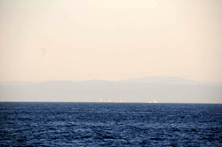
In the Zone 2:00 a.m. Japan Time Station 25; 37.5N, 141.4E There are demi stations, standard stations, and super stations. Then there are super-duper stations. At a little before midnight, we arrived at Station 25, our closest approach to the Fukushima Daiichi nuclear power plant that is the source of the radiation we are trying to measure. We plan to spend 12 hours here doing extra net tows, an extra-long surface pump, and perhaps an extra CTD cast. Fortunately it’s shallow—a little over 100 meters—so at least the CTD casts will be very short. Tricky, given the depth, but short. The Methot net is currently in the water under an almost-full moon, and a Japanese coast guard ship is keeping a wary eye on us from just inside the 30-kilometer exclusion zone around the reactor complex. They pulled in close to question us when we came on station earlier, but eventually let us continue without too much fuss. We are continuing to measure radiation in the air and water, as we have been since we left the dock, but it remains far below the level of concern. In fact, we’re still receiving a background dose of radiation that is one-sixth the average daily dose on land. That’s mainly because we are not surrounded by rocks and concrete buildings—known sources of things like as radon. We are, however, detecting the presence of cesium-134 in the water, and there is only one likely source of that particular isotope—the damaged reactors at Fukushima just off to starboard. Determination of the exact concentration will require more precisely calibrated instruments than those we have on the ship (bulky precision equipment does not always take to sea very well). What we can tell for now is that the amount of cesium-134 in our samples is lower than that of potassium-40, the most common naturally occurring radioactive isotope in seawater. The larger questions—those that we are working towards with this cruise—include the full range of isotopes that were released from the reactor that and may yet be released, how fast and by what paths cesium and other isotopes are being diluted into and removed from the North Pacific, and how these different substances might be assimilated into different levels of the food chain. From that relatively straightforward set of questions, there are yet more that need to be answered that are beyond the scope of our work: How much seafood is safe to eat? What is the risk presented by different types of seafood? What parts of the ocean are safe to fish and when, if ever, will the most heavily contaminated regions become safe again? It’s frustrating not to get immediate answers to these latter questions, especially for the Japanese people, who rely so much on the ocean for food. As difficult as this cruise was to organize and as complicated as our measurements are to make, it seems the tough part is yet to come—translating our science into sound policy decisions. It almost makes sitting here within sight of four horribly damaged nuclear reactors feel like the safe place to be.
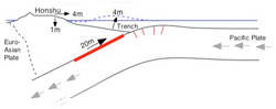
The Cause of it All 12:00 p.m. Japan Time Station 23; 37.5N, 142E I’ve touched on marine chemistry, physical oceanography, and marine biology over the past few days, now it’s time to delve into the dark arts of marine geology. Dark because much of what marine geologists study takes place deep beneath the bottom of the ocean. Late last night we made our closest approach to the epicenter of the March 11 earthquake that began the chain of events leading to this cruise. The quake registered magnitude 9—one of the largest on record—and ruptured nearly 300 miles of fault beginning 20 miles beneath the surface of the seafloor. The type of fault that broke is part of what is known as a subduction zone because it is a place where one tectonic plate in the jigsaw puzzle of Earth’s crust is forced beneath, or subducts under, another plate. Off the east coast of Japan, the Pacific Plate is slowly being pushed under the Euro-Asian Plate. Much of the Japanese island chain experiences frequent earthquakes as a result. The rate that tectonic plates move is not great, only about an inch per year on average, but where they meet they are often locked together. Over time, the plates bend and deform, building up stress that is periodically released in the form of an earthquake. Many factors govern the size of an earthquake—the geometry of the fault, the type of rocks at the interface—but for the most part, subduction zones are responsible for most of the largest earthquakes on record. Subduction zones are also the source of most tsunamis, which are caused when large portions of the seafloor change shape suddenly, displacing huge amounts of water. This most often happens when a submarine earthquake ruptures the ocean bottom or when an underwater landslide moves vast quantities of rock and mud. In the case of the March 11 earthquake, movement of the Pacific Plate was causing the Euro-Asian Plate to bend downward. When the fault ruptured, the Euro-Asian Plate suddenly snapped out and long section of the plate, including many parts of the island of Honshu, moved several meters to the east as the stress along the fault was released. Many earthquakes do not break the surface of the seafloor, but this one evidently did, creating a pulse that spread out in all directions through the water. In the open ocean, a tsunami usually appears to be no more than a few inches high, but unlike a surface wave it reaches to the bottom. When it approached shallow water the tsunami (actually a series of waves), rose up, revealing its full height and breadth and swept miles inland in places. Meanwhile, the fault that broke readjusted to its new configuration for weeks by releasing hundreds of aftershocks, several of which were significant events in their own right. The rupture also increased stress on the edges of the segment that broke, raising the likelihood that another large earthquake will occur further north or south along the fault in the future. Whether the next one will also create a tsunami is an even deeper part of the dark arts that would take far more time and an internet connection to work through.
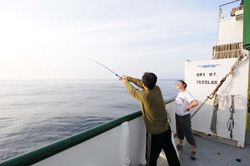
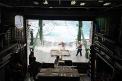
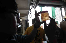
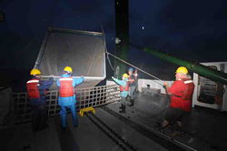
All Work, a Little Play 2:00 Japan Time Station 21; 25N, 142.5E We’ve entered a stretch that calls for us doing five so-called “super stations” interspersed with what we’ve termed “demi stations.” Our standard sampling station includes a CTD cast to 1,000 meters with a net on the wire that gathers phytoplankton from the top 100 meters, four Bongo net tows to look at zooplankton and small fish at about 250 meters, and a three-hour pump to filter cesium-134 and -137 out of surface water. (Since confirming that daytime tows with the big Methot net were not gathering much, the biologists suggested doubling the Bongo tows during daylight to increase the sample size that it is bringing in.) All of this takes about four hours. On a three-hour demi station, we do only two Bongo tows and the usual CTD cast, but without the phytoplankton net. On a super station, we pull out all the stops. In addition to the standard sampling menu, we add a Methot tow (if it’s dark) and a 200-meter cast with four battery-powered pumps attached to the wire at 20, 50, 100, and 200 meters. These pumps contain a series of filters that capture small particles in the water, radioactive isotopes that stick to those particles, and cesium, which is one of the isotopes of particular concern coming from Fukushima. After three hours, the pumps have filtered about 1,000 liters of water and shut off automatically. Last night, we also made a 2,000-meter CTD cast. While the pumps are running, Crystal Breier is on the stern deck filling three large garbage cans with seawater water that she filters slowly (at one liter per minute) to extract radium. Radium is an element that originates on land and has several naturally occurring isotopes, two of which have relatively short half-lives, so any signs of those would indicate that there is groundwater from the nearby coast of Japan mixing into the ocean around us. On top of that, Hannes Baumann, one of the biologists from SUNY Stonybrook, has begun hanging a long line off the stern at super stations to catch something a little further up the food chain than the Methot net will bring in. So far, we haven’t had much luck, but the local wildlife has discovered that there’s bait to be had and we’ve become very popular with a host of seabirds (Laysan’s albatross and northern fulmar are two we’ve identified so far) and a pair of very curious furred seals. All of that together gives us a suite of water samples from the surface to at least 1,000 meters that will be tested by us and by collaborating labs around the world for nearly twenty different radioactive isotopes. In addition, we’re taking biological samples ranging from phytoplankton up to (hopefully) large predators at nearly every station. Much of this bears repeating from earlier posts, as the pace of sampling will pick up considerably over the next few days and I’ll most likely be referring to many of these methods again soon. Last night was a warm, quiet night with an easy swell moving up from the southeast. A group of us stayed on deck while the pumps ran and we did little else but stare at the orange float marking the top of Hannes’ line. A few people tried casting one of Jun Nishikawa’s homemade lures off the other rail, but even that seemed like too much effort and eventually we all fell into an easy rhythm of joking, swapping stories, and prolonged periods of silence. From here, we begin a zigzag course to the west, alternating between demi stations and super stations. Instead of watching sunsets from the stern, there will most likely be an increasing backlog of samples to process.
Tracers II 12:00 Japan Time Station 18; 37N, 143E We’ll come back to tracers in a bit. There are a couple of changes to report, first. For one, the weather has eased considerably. Seas are easy and the sun is just barely shining through a hazy sky. About the only wind out there is whatever we can generate with forward motion. Most of us got a good night sleep and are now well in tune with the rhythm of our daily sampling schedule, so there is suddenly enough time to do things like check pumps, rig a long, or (for me) shoot more photos and video footage of little details on the ship. There is also more debris in the water—broken lumber, ripped tarps, chunks of Styrofoam—some of which was probably washed out to sea by the tsunami on March 11. We’ll undoubtedly be seeing more as we get closer inshore, beginning tomorrow. Which leads me to our second change. Instead of working our way toward shore in a series of four-station legs, we are going to cut across the top of the inshore “box” by zigzagging between the top two stations of each leg. That will help get us to the innermost leg quicker and give us a little buffer in case we have more bad weather and have to stop work again. Because it’s closest to the nuclear reactors at Fukushima, that inshore leg is important enough that we don’t want to leave it to the last thing. The only reason we didn’t start inshore and work our way out is because Ken didn’t want to potentially contaminate our sampling equipment with the slightly higher levels of radiation we expect to see there. We’ll just have to take extra precautions when we work our way back offshore to fill in the box and, if we have time, to complete the stations we had to abandon yesterday because of weather. The radiation is, of course, one of the main reasons we’re here. As far as we know, this cruise is the first comprehensive study looking at the fate of Fukushima radiation both in the open ocean and the biota. The samples we gather will help give a better idea of how much radiation is out here, where it’s going, how quickly it’s mixing into the ocean, and how it is working its way into the marine food chain. I’ll address that aspect in the next few days. But the radiation released from Fukushima also has implications for oceanography in another way. Many tracers that help oceanographers study physical and chemical processes in the ocean are radioactive. Some of these are natural—isotopes of thorium, uranium, and radium, for example—and some are there as a result of human activity. This latter group includes isotopes of plutonium and cesium deposited in the ocean by atmospheric nuclear weapons testing in the 1950s and 60s or by releases from Chernobyl, Sellafield in the U.K., and Cap le Hague in France. Whether natural or manmade, radioactive tracers are important because each has a particular origin and behavior. Some naturally occurring radioactive isotopes are formed continuously as cosmic rays interact with the atmosphere (carbon-14 is one). Others, the so-called primitive isotopes, were generally formed millions or billions of years ago In the ocean, each of the isotopes has its own particular behavior. Some dissolve, mixing and moving with their “parcel” of water over time and distance. Others adhere to particles and sink to the bottom, accumulating in layers at the bottom, or are consumed by animals at the base of the food chain that graze on marine snow—bits of organic matter in the water. Each isotope also has an internal clock that allows oceanographers to study processes that play out over different time scales, such as water transport from one ocean basin to another or sedimentation rates in the deep ocean. This clock, the half-life of each isotope, is the time it takes for one-half of the atoms in a particular sample to give off radiation and decay to its so-called “daughter” products. Iodine-131, for example, has a half-life of eight days, which means that after that amount of time, half of it will decay to form xenon-131, which has its own half-life and behavior in the environment. The accident at Fukushima injected a whole new suite of radioactive tracers into the North Pacific, each with its own behavior and half-life, that will almost certainly be used by oceanographers to extract information from the ocean for decades to come. In fact, Ken started his career studying radiation from nuclear weapons in the Pacific that was carried to the Atlantic and isotopes released into the Black Sea from Chernobyl. There very well may be someone on this cruise whose career is being similarly forged.
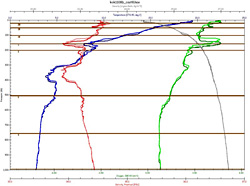
Tracers 2:00 p.m. Japan Time 35N, 143E It’s Saturday, so I’m going to let someone else do some of my work for me today. In his book Seven-Tenths: Love, Piracy, and Science at Sea, WHOI’s David Fisichella does as good a job as anyone in describing the way that chemical oceanographers use tracers to study the ocean—something that will be of particular importance this coming week: The oceans are in constant motion, circulation in and out of basins and around continents. The water in the North Atlantic may take hundreds of years to circulate around back to its point of origin. As these parcels of water move about, their properties, i.e., salinity, dissolved oxygen, and temperature, change. This change, however, happens very slowly. Oceanographers look at these properties as a forensic scientist looks at fingerprints, and by taking careful measurements can tell where the water originated. In some cases, other elements have been introduced into the water from external sources; these can include nuclear fallout and pollutants. These elements, called tracers, can be used by oceanographers to follow the path of water for thousands of miles. This idea that there are discrete, identifiable “parcels” of water beneath the surface seems counter-intuitive at first, but if you look at the CTD plots from yesterday, you’ll begin to get a sense of this. It forms the foundation of much of our knowledge about the world’s ocean and will play a large role in what we continue to do throughout the coming week and for years to come in studying radioactive releases from Fukushima. Today, however, our search for these parcels has come to a grudging halt. Fifty-knot gusts and 7 meter waves have made it impossible to do much of anything except catch up on work or sleep. Last night, we attempted to make a 2,000 meter cast with the CTD rosette, but we were obviously back in the Kuroshio current. A 4.5-knot current combined with 40-knot gusts to send the CTD wire out behind the ship at an awkward angle. With nearly 1,700 meters of wire out, we just barely made it to 900 meters depth. Then, before any bottles could be tripped, the wire angled the rosette up even further to 720 meters. But that’s what happens when you go out on the ocean looking for answers. Sometimes you are stymied by the very thing you want to study.
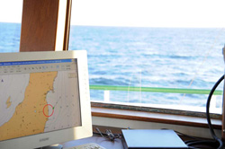
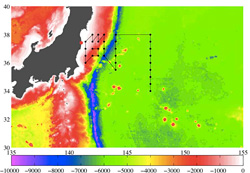
Lines in the Water 10:00 a.m. Japan Time Station 10; 38N, 144E Last night we came to the end of our first sampling line, the furthest offshore. Everyone was looking forward to a little down time (even the people on the midnight to noon watch) and there were grand plans floated to watch movies or get caught up on work. A few stayed up, but after dinner, people mostly just filtered away to bed. It was probably for the better. After only 14 hours, we arrived here at Station 10, the bow pointed down a fresh line of sampling stations. At 6:00 a.m. sharp, the Methot net went in the water and we started all over again. This time, though, we are going to stop two stations short and turn for the in-shore legs a little early. On the early part of the first leg, we were bucking a 4.5-knot current that cut our headway in half and put us almost a day behind schedule. Like the Gulf Stream, the Kuroshio is not a single, pipe-like flow of water. Instead, it meanders, splits into smaller streams, and sometimes bends back onto itself forming eddies that swirl far north or south of the main branch of the current. On our way up the first leg, we apparently ran head-on into one of these small streams, or filaments, and couldn’t do anything except continue to bull our way through. Eventually, the filament turned away from our intended course. John Gall, the chief mate, said and the surface of the ocean changed noticeably when it did and the ship surged forward. One of our physical oceanographers on board, Steve Jayne, said these features are difficult to model because they are so chaotic and so small. They are, however, very important to understand, as they can impede shipping, resulting in increased transit times (as we experienced) and shipping costs, or even slow down ships responding to a mayday. On the open ocean, that can mean lives lost. It can also work both ways, of course—another of those filaments carved an hour off of our expected transit time overnight to Station 10. In the Gulf Stream, swordfish and other predator fish tend to congregate along filaments, giving them added biological and commercial significance. We’re interested in fine features beneath the surface, as well. With every rosette cast, a group forms around the instrument display in one of the labs to watch traces form from the oxygen meter and CTD sensor (reading salinity, temperature, and pressure). The physical oceanographers read those graphs like a story that tells the origin and evolution of water at different depths. The chief scientist, Ken Buesseler, can then refine his sample plan on the way back to the surface in order to get water that might be more interesting slightly above or below where he’d originally planned to trip one or more bottles. Recently, for example, we’ve been seeing signs of fresher, colder, more oxygenated water somewhere around 300 or 400 meters. Water in the Kuroshio flows up the tropics and as a result is generally saltier (because more water has evaporated), less oxygenated, and warmer than water further north of us. It’s possible, therefore, that the blips we see in the salinity, temperature, and oxygen data are either water from the northern mid-Pacific being mixed in by the movement of the Kuroshio through the open ocean. More crucial to this cruise, however, is the possibility that it could be a signature of surface water that traveled down the northern coast of Japan with the Oyashio current, past Fukushima, and then out to us along the Kuroshio. If it is, we should be able to see signs of radium in the samples we’ve taken from those depths. Radium is a naturally occurring radioactive element that only comes from sources on land, including ground water flowing into the ocean. So if we see both radium (which we can test for on board) and cesium-134 and -137, then it’s a good bet we’re on the right track. We’ve also begun deploying Argos drifting buoys so that oceanographers back on land can track and better understand the movement of the Kuroshio and its many mystifying features.
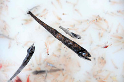
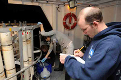
Chasing Fish 3:00 p.m. Japan Time Station 9; 38N, 147E We had one good net haul after sunset yesterday and had a second around midnight cancelled due to weather that the biologists were sad to miss. Then early this morning, as soon as the sun came up, the net came back almost empty. What we were seeing is almost certainly tied to one of the greatest migrations on Earth, one that happens every day all over the world, but (unlike the African savannah) one that goes on largely unnoticed and beyond the view of National Geographic cameras. Every night, countless small fish and zooplankton rise to the surface to feed on the tiny phytoplankton that lives in the upper ocean within reach of sunlight. As soon as the sun rises these animals all descend to darker waters looking for shelter from larger predators. It’s difficult for the biologists on board to see their empty nets, to know what’s happening, and to not go chasing deeper after more fish. As Hannes Baumann said, “You want to adapt, but you have to be consistent. You want the nets to be full. It’s also hard to just say ‘That’s the way it is.’” I may have mentioned this earlier in a caption, but Hannes and Jennifer George from SUNY Stony Brook are working with Jun Nishikawa and Hiroomi Miyamoto from Tokyo University to do the biological surveys on this cruise. They have three nets at their disposal: the “small net” that gets clamped onto the top 100 meters of the CTD wire to collect phytoplankton in the upper ocean, the Bongo net that collects larvae and other animals larger than one-third of a millimeter, and the Methot net, which brings in juvenile fish, shrimp, and big plankton about 4 millimeters and larger. The phytoplankton samples are filtered and will be analyzed for chlorophyll content back on land. The Bongo and Methot net samples are divided, with ninety percent destined to be freeze-dried and ground up for radiochemical measurements back at Stony Brook and for additional, more labor-intensive analysis at Oregon State University. The remaining ten percent will be identified for species composition and distribution by our Japanese colleagues, who have particular expertise in what lives in these waters. From that, the various groups involved will be able to assemble a picture of how productive these waters are and what and how much lives here. Comparing this to the amount and type of radioactive isotopes we find in the water will then tell more about how much of which substances is actually being assimilated into and passed among the lower levels of the food chain. As with the chemistry, however, much of the biological analysis will also need to wait until we return to shore. Many of the tests that will be run have to be done in ultra-clean facilities over a period of weeks and months or require instruments that we could not take to sea. Observationally, it appears that sometime during the night we crossed a line—from the warmer waters of the southern North Pacific to the colder, nutrient-rich northern waters that help make this area one of the most productive fisheries in the world. Where the two water masses meet and mix, large predators like tuna tend to congregate so they can make quick forays across the boundary to feed on medium-size fish that live in colder waters. Jennifer is seeing signs of this transition in sharp increases in phytoplankton. We’ll see if the trend continues in the nets that will be going out over the next couple of hours. The cold water has also created dense fog, and as we approach our final station on this leg, we are surrounded by a wall of white. One lone bird—possibly an albatross—circles the ship, dipping in and out of the fog with barely any effort while we labor away with nets and bottles and winches.
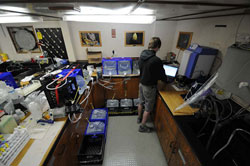
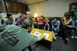
Connections 6:30 a.m. Japan Time Station 4; 35.50N, 147E Today is World Ocean Day. Sort of snuck up on me because the ship sort of exists outside of time and I’m not really looking at my calendar except to label my blog posts. Hard to imagine a more fitting place to spend the day. We now have six teams working 12:00 to 12:00 with a few of our most experienced ocean-going scientists and technicians working slightly offset shifts so that they overlap with both groups. There are three sets of teams, as I may have mentioned before: physical, chemical, and biological. Each has their own responsibilities, but there is quite a bit of overlap, so it isn’t uncommon to see one of the biologists helping out on the CTD deck, for example. In much the same way that our operations are coordinated and overlapping, the ocean’s physical, chemical, and biological systems are intertwined, as well. Oceanographers look at the chemistry of the water and examine chemical tracers (including radiation) to understand the physical processes governing the movement of water between ocean basins or between ocean and atmosphere. They look at the physical processes beneath the surface to help understand more about the marine organisms that can move thousands of miles each year or that stay in one place all their lives. And the state of those same living things can tell us about the water they live in or that they’ve recently passed through. Just a generation ago, it would have been unheard of to organize a physical oceanography cruise and invite a biologist along, or visa versa. These days, it would be rare not to. The signs of radiation that we’re looking for are, we expect, going to be extremely slight. In fact, at the moment we’re receiving a dose of radition that is noticeably lower than the one we were detecting on shore and indoors, and almost certainly far lower than what we experienced on the flight to Tokyo. We’re taking samples of water, air, and biota (mainly the lowest levels of the food chain) to test for a suite of more than a dozen different radionuclides. These natural and man-made radioactive elements include isotopes of potassium, uranium, and thorium that are always present in sea water as well as the telltale fingerprint of releases from Fukushima and Cold War nuclear weapons testing that show up in cesium-134 and -137 and the short-lived isotopes of iodine. Many of the samples we’re taking will not be analyzed onboard. In fact, the refrain here has been that we will leave the ship with very little data. What we will have instead is a wealth of samples that we are pre-processing and packaging to send to labs all over the world with specific expertise in studying one isotope or another. Observationally, we’re getting a better idea of what’s going on in the ocean beneath us with every CTD cast and with the return of every net. Steve Jayne knows the Kuroshio current as well as almost anyone and he’s looking at the plots of salinity, temperature, and oxygen together with water velocity that comes off the ship’s acoustic Doppler current profiler to build a more detailed picture of how that current is mixing and mingling with large masses of water north and south of us as well as with water from the coast of Japan. One of those fine details that make the Kuroshio so interesting, a surprisingly strong 4.5-knot stream within the main current, has been holding us back for the past day or so. We’re out of it now, but we still might have to trim a few stations off this and the next leg in order to make sure we have plenty of time to get samples from the critical near-shore locations. That is yet another hallmark oft-repeated truism in oceanography: you never go to sea with a plan that is either inflexible or lacking options. We’ve built in both, but will still have to take what the ocean gives us.
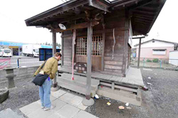
Why We're Here 2:30 p.m. Japan Time 34.07N; 145.55E We’re on our way to the first sampling station. Now it’s all about finalizing water budgets—making sure we get enough water at the right depths to meet the needs of all the different groups who will be doing work on the ship and back on shore. It’s all about making sure the right samples get drawn and processed or stored properly and about making sure the biologists have enough time on station to trawl at the right depth. It’s all about making sure everyone knows what they’re doing and that we have the right people on duty at the right time. It’s about countless tiny details. But this is all about something else, as well. Something much bigger. We might be out here to do basic oceanography, but we are also here on the heels of an unprecedented geophysical event that has had massive human cost. So Ken Buesseler and I took a shinkansen (bullet train) up to Sendai about 200 miles north of Tokyo to see for ourselves what remains the physical effects of March 11. With a population of one million it is the largest city in the Tohoku region that was most heavily affected by the magnitude 9 earthquake and tsunami. The epicenter of the quake was in the seafloor just 80 miles to the east of Sendai. At first, I was hard-pressed to find any sign that even a small tremor had occurred. Having been to Kobe immediately after the 1995 earthquake, I knew to look for blue tarps on rooftops (traditional Japanese homes have heavy roof tiles that often shake loose and slide off during earthquakes) and cracks in walls, particularly in the corners of windows. But the other things that were common in Kobe—pancaked buildings, buckled streets, large areas of burned houses—were not visible. We took a cab to a Shinto shrine I’d read about in the southeast part of the city. Namiwake Jinja was first built in the aftermath of the Jogan tsunami of 869 A.D. because the ground it now sits on was spared inundation. This time, as well, the tiny shrine building and the immediate neighborhood were largely unscathed. That’s fortunate because, in addition to the community center next door and the many homes nearby, the area is also home to a large helicopter for the Japan Self-Defense Force from which relief efforts continue to be based. Our cab driver, Mr. Sasaki, is from Sendai, but had no idea the shrine even existed. He thanked us for telling him about it and showed us how to pay our respects in the traditional way: two claps, two bows, one clap, and a ring of the bell. Ken and I had originally planned to then make our way to the airport and walk the half mile or so to the ocean before catching a bus back to the Sendai train station. But then Mr. Sasaki said he could take us someplace where we could see the effect of a 15-meter tsunami—a “ghost town” he called it. From the highway, we could begin to get a sense for the nature of the destruction. Wide swaths of homes were stripped down to the foundations and the rubble strewn about in between. Boats and cars lay in jumbled heaps. Dead trees, poisoned by salt water, stood between untended and unusable rice paddies. But that was only on the left side of the car. The highway is built on a raised roadbed, so it acted like a long dike. Except for a few places where water surged through underpasses, the homes and fields on the right side were largely unscathed. In a way it was reminiscent of the way a tornado can rip through a town and leave one street unscathed while just a block away looks as if a buzz saw passed through. We got off the highway at a town called Nattori—or rather we got off where Nattori used to be. Only a few houses still stand where there was obviously once a thriving little community. Work crews are already hard at work removing debris, but standing in the middle of an open and jagged horizon, it was hard to believe they could ever put such utter devastation back in order. People may want to move back there because that’s what many people seem to do when their homes have been destroyed. Rebuild. But nothing will grow there for years. Rebuilding to something resembling what Nattori was will take even longer. And there will always be the memory of that day the ocean rose up and took the land. We got out in front of a Buddhist temple and walked around a bit, but didn’t stay long. The few houses remaining were split open and spilling their contents into the yard or the street. A few lone items were lined up in front of one as if asking: “Whose are these?” But who will come by to claim them? We got back in the cab and drove to the airport in silence. Along the way we passed a woman squatting in front of the remains of her house, carefully picking through the mud in what was probably once her garden with a tiny hand trowel.
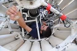
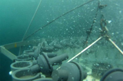
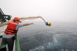
Testing 1, 2 . . . 7:00 p.m. Japan Time 34 24N, 142 41E (100 nm west of Japan) Today was a test day, starting with the obligatory one long bell that signals all hands to muster at their emergency stations. For us in the science crew, that means we grab our life vests and survival suits and head to the top deck to be counted. After that, we began preparing for a dry run (if there is such a thing on the open ocean) of all our sampling equipment and procedures. First in the water was the bongo nets. These small, hoop-shaped nets will collect zooplankton as small as 300 microns—one step up from the base of the marine food chain. Next was the rosette sampler, the iconic assemblage of 24 sample bottles that is a mainstay of oceanography. The rosette frame also holds instruments to measure salinity, temperature, depth, chlorophyll, oxygen, turbidity, and light penetration from the surface that will help us generate a picture of how waters from the east-flowing Kurashio current is mixing with its colder cousin, the Oyashio (more about these two in future posts). Last in the water as the rain started falling was the big Methot net, a two-meter-by-two-meter frame with a long, pyramid-shaped net that we towed down to a depth of 200 meters. It will give us an idea of the composition and health of macro plankton (new Scrabble word: nekton), including small shrimp and fish. Hannes Baumann and Jennifer George from SUNY Stony Brook together with Jun Nishikawa and Hiroomi Miyamoto from Tokyo University will be getting wet hauling in and sorting those samples over the next two weeks. The testing even extended to documenting and reporting, as I discovered that salt spray on a lens does not come off with a wipe from a similarly salty t-shirt (it just smears more) and that the little E in my camera’s display means the memory card is not recording and needs to be reformatted. Good to know—and a good thing there will be 34 more opportunities to re-create the dozens of photos that were lost. It was also a day of very real work, as several other sampling regimes are already well under way. Last night, for example, we began our first aerosol sampling. There was a tense moment when the instrument wouldn’t start. There’s no service number we can call out here, so Jun and Hiroomi poured through the Japanese operating instructions on the upper deck by flashlight. Fortunately, it wasn’t serious—a light switch that was turned off also controls the outlet it’s connected to. Jarvis Caffrey, a first-year graduate student in nuclear engineering at Oregon State University is on board to monitor radiation levels in the water and air. He’s running a sodium iodide detector—an instrument that is looking for signs of radiation in the seawater around us. He’s also taking swab samples on the ship’s rails periodically to look for signs of airborne radiation. So far he hasn’t found anything out of the ordinary, and his radiation alarm has remained blissfully quiet. Tomorrow the fun begins—and the real work. We should be on our first station at around 7:00 p.m. local time. We’ve split the science crew into two, 12-hour shifts so half of us are starting to think about re-setting their internal clocks. There is, however, only one writer and photographer to cover round-the-clock operations. Fortunately, there’s an espresso machine in the wet lab. More about that later.
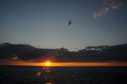
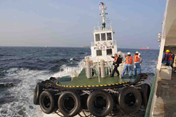
To Sea We are under way. At 2:30 p.m., our Japanese pilot came aboard (very dapper in his blue suit and fedora), a tug tied up to our stern, and by 3:00 sharp we had slipped our lines and were edging away from the dock into the busy Tokyo Harbor traffic. Tourists on the upper deck of the international ferry terminal waved us off and a soaring raptor dipped its wings in the updraft from our stacks. Our trip will study the fate of radiation released into the ocean from the Fukushima Daiichi nuclear power plant that was badly damaged by a tsunami on March 11. There was probably little, if any, doubt in the mind Ken Buesseler, the chief scientist, that we would eventually be under way, but there were some difficult times over the past weeks when permissions to sample in Japanese waters were still in limbo. Added to that is the inevitable mountain of detail and mountain of gear that must be put into order to organize a cruise of this scope and complexity. But he and the others were able to make it all happen, and in near-record time. There are still things that could go wrong, unforeseen complications that might arise, but we’ll deal with those in time. For now, one major hurdle has been surmounted: we are at sea and our bow is pointed to open ocean. Tomorrow we’ll make a test cast of the instruments and nets to iron out the kinks in our sampling procedure. Two days from now, we’ll be on our first station and all the mountains of paperwork, the late-night phone calls, and rushed planning will matter not one bit. All that will matter is the information we can tease out of the ocean. Last updated: March 8, 2012 | ||||||||||||||||||||||||||||||||||||||||
Copyright ©2007 Woods Hole Oceanographic Institution, All Rights Reserved, Privacy Policy. | ||||||||||||||||||||||||||||||||||||||||