Please note: You are viewing
the unstyled version of this website. Either your browser does not support CSS
(cascading style sheets) or it has been disabled. Skip
navigation.
Hello Mrs. McMahon and all your students, These are great questions! I hope we satisfy you with our answers and hopefully we will spark a few more questions. Enjoy the VANISHING ARCTIC website, we have much more to add to it. - Pat Keoughan Hello from Blakely School. We have some questions for you. Thank you for letting us ask them. QUESTION 1 IN REGARD TO THE CURRENTS, IS THERE MORE COLDER, DENSER WATER THAN WARMER, LIGHTER WATER IN THE BEAUFORT SEA? HOW MUCH TEMPERATURE DIFFERENCE IS THERE BETWEEN THE SURFACE AND THE DEPTHS? Answered by Dr. Bob, Chief Scientist: Great question! When people think of the Arctic Ocean they usually envision bitter cold air, pack-ice, and cold water. And this is true much of the time. However, we purposely choose to do our work north of Alaska during the time of year (August-September) when the pack-ice has thinned and the water is warmer. One of the reasons why the water is warmer is because the sun heats it up. But another reason is that, during summer, warm water from the Pacific Ocean flows through Bering Strait northward into our working area. This year the Pacific water was really warm...warmer than 45 degrees Fahrenheit! (Well, maybe you won't call that warm, but by Arctic standards it's downright hot.) However, when we lowered our instruments into the water the temperature dropped quickly. Near the bottom the water sometimes got as cold as 30 degrees Fahrenheit. Yes that's correct, the water was colder than the freezing temperature! Do you know how that can happen? Here's a hint: what substance do snowplows spread on the road during winter? And what does that substance do to the frozen snow?
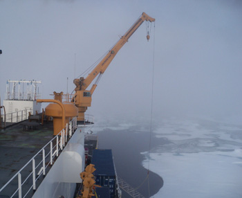
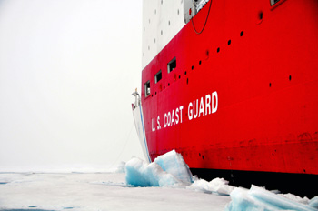
Answered by Pat Keoughan, Outreach, and some of the Healy crew in the Engine Control Center : Interesting question! The HEALY does not change the saltiness, temperature or anything about the currents here in the Beaufort. It can minutely change the chemistry of the water right next to it. Scientists wanting pure Arctic water will collect it off the bow, not the back of the ship. Everyone, though, is very conscious about not causing any harm. The National Science Foundation (NSF) and the science group aboard are responsible for including a Community Observer on the cruise to make sure we don't interfere with the Native villages of the North Slope of Alaska, especially their fall whaling. ( Look at the INUPIAQ PERSPECTIVE section of our website for our Community Observer, Elizabeth Rexford's, view of our cruise.) The Healy has won awards for its recycling program. It has an incinerator and trash compactor onboard. The OWS system that filters oil out of seawater that gets into the ship so it can be returned to the sea is used when they are at least three miles off shore. The CHT System processes the sewage onboard so it can be returned to the ocean, again, at least three miles off shore. There are recycling containers and posters all over the boat and the crew is careful to use environmentally safe materials. Answered by Ensign Holly McNair The USCGC Healy essentially does not affect the current or natural climate of the Arctic Ocean simply by being here. In order to minimize our pollution the cutter abides by strict recycling protocols that are established by the federal government to protect the ocean and marine life. Firstly, the ship recycles through separation of our trash. Basically, in everyone's stateroom and all throughout the ship there are four types of trash cans. One is for wet trash (all food waste), second (paper), third (regular trash- like a candy wrapper), fourth (bottles and cans). Since the ship is underway for so long, we have to store all the trash onboard until we get to land. If we had to store all of this trash it would take up a lot of space on the ship and smell awful. To prevent this from happening, the ship by law is allowed to put food waste in the ocean. The water will naturally break down all the food particles and it will disintegrate into the ocean. The same thing happens when we use the bathroom, all of that waste goes to a tank and when we are far enough from land we can put that into the ocean to disintegrate and naturally be absorbed (similar to the decomposition of an old tree into the soil). The other trash is put into large, sealed storage containers outside the ship, to keep it away from everyone inside the ship, prevent the bad smell, and stop the spread of germs. Once we reach land we place the other trash in a regular dumpster and recycle the paper and bottles. Things like plastic and bottles do not naturally dissolve thus polluting the ocean, and this is why we do not put them in the ocean. Last year the USCGC Healy was awarded the 2009 Commander Joel Magnusson Innovation Award for Management, for Shipboard Waste management/Recycling. The recycling program the ship abides by is very effective and environment friendly. QUESTION 3 HOW STABLE IS THE ICE IN THE BEAUFORT SEA? Answered by Pat Keoughan: Icebergs break off of glaciers into the ocean. They can have rounded parts, be different shapes, even be bigger on top than the bottom so they can tumble and may not be very stable. There are no glaciers flowing into the Beaufort Sea.
Answered by Pat Keoughan: I used the data collected by the instruments aboard the HEALY to find a graph showing the air and sea temperature for the last 24 hours. I've recorded the highest and lowest for you to give you an idea of the temperatures we are experiencing. These temperatures are from 9/14/10 at 3:30 PM, or 23:30 as we tell time onboard. I rounded numbers to the nearest 5 tenths. The sea water surface temperature high was 5.25 degrees C (41.5 degrees F) and the low was 2.25 degrees C (36 degrees F). The air temperature was a bit trickier. I went to the bridge where the Coast Guard crew drives the ship. Seaman Burgeson helped me by looking up the highest air temperature during the last week, 49 degrees F, and lowest, 36 degrees F. The highest surface seawater temperature was 47 degrees F and the lowest, 30 degrees F. QUESTION 5 IF ALL THE ICE MELTED IN THE ARCTIC OCEAN HOW MUCH WOULD THE SEA LEVEL RISE AND HOW MUCH FRESHWATER WOULD THAT BE? Answered by Melinda Webster, Physical Oceanography Graduate Student: For the amount of sea level rise from melted sea ice, the short answer is not much. The best way to explain this is to think of freezing a glass of water. Say you measure the water level before placing it into the freezer, remove it 24 hours later and measure it again once all of the ice is melted. You'll find that the water level is the same as before. Melting sea ice, for the most part, acts the same way. It's formed from water already in the ocean and when it melts, it doesn't significantly contribute to sea level rise because the frozen volume equals the melted volume. For the amount of freshwater from sea ice melt, we have to make some simple calculations to get a rough idea. First, let's say the average Arctic sea ice thickness is about 10 feet (0.003 km). Second, let's estimate that the amount of sea ice is about 5 million square kilometers during September. We can multiply these two numbers together to get a total surface area of 12,000 cubic kilometers of sea ice. Assuming, for this experiment, that this is all freshwater, then we have 12,000 cubic kilometers of freshwater from sea ice that melts into the ocean. In reality, this number would be lower because sea ice can actually be pretty salty. (Ben Harden did some quick math and found that this much water would fill around five billion Olympic size swimming pools! Ben went on to figure if you put these pools on top of each other they would be as high as ten trips to the moon and back.) Now if land-based ice such as glaciers and ice sheets were to melt, then yes, there would definitely be sea level rise because of the addition of freshwater into the ocean. It's estimated by the National Snow and Ice Data Center that sea level rise would increase by more than 70 meters, about 300 feet, if both the Antarctic and Greenland ice sheets were to melt. Answered by Matt Glazewski, NOAA Ice Observer: The Greenland's ice cap holds about six percent of the world's fresh water. Folks forget that even if all of the sea ice melted, first year ice will still form in the wintertime. (Check out Dallas Murphy's 9/13 daily journal on ice on this website for more about the consequences of melting ice.)
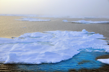
Answered by Melinda Webster: Sea ice thickness varies quite a bit throughout the Arctic Ocean. This variation can be up to 5 feet and greater, depending on the age of the ice. Old sea ice is thicker, while young ice is thinner. Ridges that form when sea ice floes collide into other ice floes can be multiple stories high. In the Antarctic, sea ice is usually thinner, with an average thickness of 3-7 feet. Sea ice thickness varies throughout time too. In 2009 scientists found that the average Arctic sea ice thickness decreased from about 12 feet to 6 feet between 1980 and 2008. They calculated this from a combination of both submarine and satellite data. If you still have questions, you can find all sorts of great information on sea ice here: http://nsidc.org/sotc/sea_ice.html. Answered by Matt Glazewski: First year ice can be as thin as paper or as thick as a meter (~3.3 feet). (On this topic, the science group received an e-mail from Matt Glazewski on 9/15/10 sharing information he had just received from the National Snow and Ice Data Center...Arctic sea ice reached its annual minimum extent on 9/10/10, at 1.84 million square miles. Steve Roberts, one of our science support people aboard explained that if you looked at the Arctic from a satellite, the least amount of ice coverage, the farthest it has melted back around the Arctic in 2010 was on September 10th. It will start growing out and getting bigger as it gets colder now. This was the third lowest pack ice minimum since satellite observations of the Arctic began in 1979.) Last updated: September 29, 2010 | |||||||||||||||||||||||
Copyright ©2007 Woods Hole Oceanographic Institution, All Rights Reserved, Privacy Policy. | |||||||||||||||||||||||