Please note: You are viewing
the unstyled version of this website. Either your browser does not support CSS
(cascading style sheets) or it has been disabled. Skip
navigation.
On this cruise, the science team is using a variety of tools to make various measurements of the ocean and atmosphere. Some instruments measure only one particular instant in time (CTD, radiosonde, VPR); others collect data over a long time period (instruments on moorings). Read below to learn about the tools scientists use to probe the cold water of the Irminger Sea. Instruments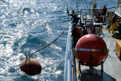 Mooring MooringA mooring is an instrument, or series of instruments, attached along a cable that extends over a portion of the water column. A flotation buoy at the top of the mooring keeps the cable taught, and a heavy anchor at the bottom keeps the mooring from moving around. A variety of instruments can be attached to the mooring line; for instance, current meters (which measure the water flow- how fast is it moving?) and temperature/salinity sensors. These instruments collect data at specific time intervals and store the data until the mooring is recovered at a later date. 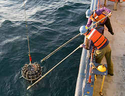 CTD CTDCTD is an acronym for the parameters that this device measures: "Conductivity (saltiness), Temperature, and Depth." The CTD itself is a set of small probes attached to a large metal rosette wheel (see image). The rosette is lowered on a cable down to the seafloor, and scientists observe the water properties in real time via a conducting cable connecting the CTD to a computer on the ship. The water temperature and salt content, or salinity (which is computed from the conductivity), is important to oceanographers because it tells us about the types of water masses present, and how they are moving in the ocean. There can also be a host of other acessories and instruments attached to the CTD package. These include Niskin bottles (gray bottles in image) which collect water samples at discrete depths for measuring chemical properties, Acoustic Doppler Current Profilers that measure the horizontal velocity, and oxygen sensors that measure the dissolved oxygen content of the water. 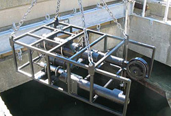 VPR VPRThe VPR is essentially an underwater microscope used to take pictures of zooplankton. A video camera mounted in one of the arms focuses on a point midway between the two arms. A strobe on the other arm illuminates the imaged volume and flashes 15 times per second, producing 15 high resolution, color images per second of the particles and plankton in the water. The images are saved internally on a computer hard disk. The instrument is mounted in a frame (see photo) and lowered into the water from the stern of the ship. A CTD also is mounted next to the VPR to collect depth, temperature, and salinity information at the same time as each video image. The instrument is lowered down through the water to a maximum depth of 350 meters so that we get a profile of plankton/particle abundance and type along with temperature and salinity. 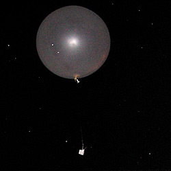 Radiosonde RadiosondeRadiosondes are a combination of a balloon and a small package of instruments. They are used to measure the atmosphere. When released, the radiosonde travels way up into the air, measuring as it goes and sending the information (height, pressure, temperature, humidity, horizontal wind speed, horizontal wind direction and vertical wind speed--at different heights) back to the ship. In areas where there are not very many weather obsevations (such as at sea), the information that radiosondes collect can improve the forecast and our understanding of the weather systems. Last updated: June 21, 2010 | |||||||||||||
Copyright ©2007 Woods Hole Oceanographic Institution, All Rights Reserved, Privacy Policy. | |||||||||||||