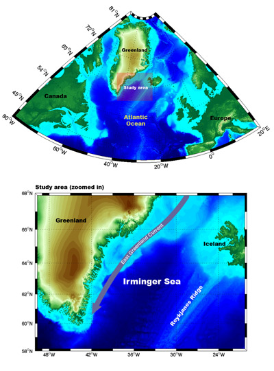
Freshwater superhighwayThe Irminger Sea, situated between southern Greenland and the Reykjanes Ridge (an underwater mountain range that extends from Iceland), is a critically important area of the North Atlantic. Currents that begin in the Arctic pass through the sea and meet North Atlantic water, forming new kinds of dense water that sinks and flows to the equator. South of Denmark Strait, along the shelfbreak, a sharp front forms where the cold, fresh outflowing Arctic-origin water meets the warm, salty recirculating subtropical-origin water. This front and its associated "jet" (a strong, narrow current)—the East Greenland/Irminger Current—is the "super highway" by which freshwater, as well as intermediate-density Arctic-origin water, is exported to the North Atlantic. The front and jet are highly unstable--as the front "wiggles" back and forth, water is exchanged across the front boundary. This is likely caused in part by the strong winds adjacent to the tall Greenland plateau. As part of the exchange process, dense shelf water appears to cascade over the shelfbreak to form a "Spill Jet" that resides below the East Greenland/Irminger Current.
Last updated: September 16, 2008 | ||||||||||||||||||
Copyright ©2007 Woods Hole Oceanographic Institution, All Rights Reserved, Privacy Policy. | ||||||||||||||||||