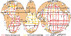
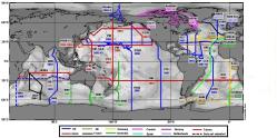
CLIVAR is one part of the World Climate Research Programme (WCRP) project. The name stands for Climate Variability and Predictability. It is a large international program that seeks to understand the processes that determine how climate varies and how it can be predicted. It focuses on the roles of the ocean, atmosphere and land surface, and the interaction among the three in climate and climate change. The CLIVAR program does this through: Variations in climate occur on many scales: that is our climate can change from season to season, from year to year, from decade to decade and century to century, as well as on shorter time-scales and longer time-scales. CLIVAR is interested in all in these changes. CLIVAR includes a US CLIVAR component and one part of US CLIVAR is the repeat hydrography program. This program is driven by the need to monitor the changing patterns of carbon dioxide (CO2) in the ocean and provide the necessary data to support continuing model development that will lead to improved forecasting skill for oceans and global climate. During the 1990's, two programs, WOCE (World Ocean Circulation Experiment) and JGOFS (Joint Global Ocean Flux Study) sought to provide a 'snapshot' of the global ocean circulation and properties through observations performed along zonal (east-west) and meridional (north-south) lines. The CLIVAR hydrography program is observing the physical and chemical properties of the ocean along a subset of the WOCE zonal and meridional lines, and is doing so repeatedly in an effort to monitor changes. The maps at the left illustrate the coverage of the WOCE/JGOFS one-time survey and the CLIVAR repeat surveys.Last updated: November 12, 2009 | ||||||||||||||||||||
Copyright ©2007 Woods Hole Oceanographic Institution, All Rights Reserved, Privacy Policy. | ||||||||||||||||||||