Please note: You are viewing
the unstyled version of this website. Either your browser does not support CSS
(cascading style sheets) or it has been disabled. Skip
navigation.
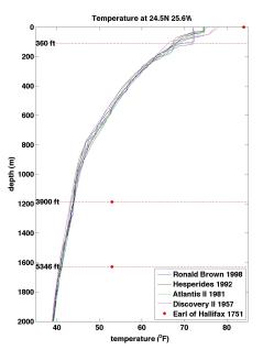
Hydrography is a noun meaning scientific observation, description and analysis of physical aspects of the ocean. It is often used to refer specifically to measurements of temperature and salinity or to the mapping of bodies of water. However, here we use the term hydrgraphy and the associated adjective hydrographic to mean the measurement of physical and chemical properties of the ocean. A hydrographic line or cruise implies that a ship steams to a particular location or set of locations (called stations), and send instruments over the side to measure at a minimum temperature, salinity and pressure. The first deep (non-surface) hydrographic measurement was taken from the ship, The Earl of Hallifax, as it crossed the Atlantic (1750-1751) as recorded in letter to the Reverend Dr. Hales from Captain Henry Ellis (Ellis and Hales, 1750-1751). Capt. Ellis used a bucket designed by Rev. Hales to collect water from a variety of depths at and below the surface. Dropping his bucket ‘sea-gage’, which included a thermometer, to depths as great as 5346 ft, he hauled it back up and observed its temperature. What he found was very interesting: “…the cold increased regularly, in proportion to the depths, till it descended to 3900 feet: from whence the mercury in the thermometer came up at 53 degrees; and that is a mile ad 66 feet, it came up no lower.” There were a number of problems associated with these measurements including: o likely leakage into the bucket of waters other than those intended for collection; o as Capt. Ellis, himself, pointed out that the since the time in took to haul the bucket up could be as long as 45 minutes, the water inside had time warm up as rose; For the WOCE/JOGFS and CLIVAR cruises whenever possible stations are no more than 30 nm (55 km) apart. At each station measurements of temperature, salinity and oxygen are taken every 2 dbars (~2 meters) from the surface to about 10 meters above the bottom. Usually water samples are taken at up to 36 different pressures and used to measure a variety of water properties such as alkalinity, pH, dissolved inorganic carbon (CO2), radio carbon, helium, tritiium, dissolved organic carbon and other organic material, chloroflourocarbons (CFCs), Along some lines trace metals and aerosols are also measured. References: Ellis, H. and S. Hales, 1750-1751. A Letter to the Rev. Dr. Hales, F.R.S. from Captain Henry Ellis, F. R. S. Dated Jan 7, 1750-1751, , at Cape Monte Africa, Ship Earl of Hallifax. Philosophical Transactions (1683-1775), Vol. 47, 211-216. Last updated: November 12, 2009 | ||||||||||||||
Copyright ©2007 Woods Hole Oceanographic Institution, All Rights Reserved, Privacy Policy. | ||||||||||||||