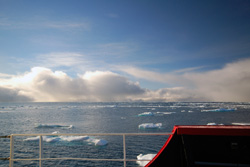
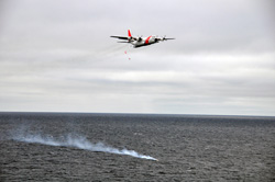
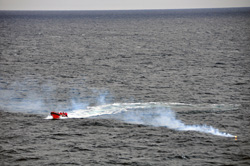
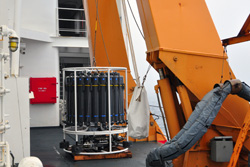
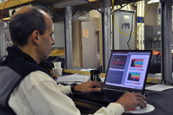
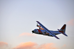
It’s a beautiful day on the Beaufort Sea, temperate-zone-style cumulus clouds and unfamiliar sun. Who would have imagined that almost three weeks above 70 degrees North would elapse without a blow. Most of the time, if you don’t walk out on deck and look, you could forget you’re afloat. I wouldn’t mention it to my shipmates, but I’m still nautically curious about how Healy behaves in a seaway. In a day or two, we’ll complete the science and head east for the Bering Strait then south for Dutch Harbor across the Bering Sea, where we hear some very heavy weather is ripping through the Aleutian Islands. I mean, I’m not hoping for dirty weather, no kidding, just interested to observe her motion in it. But I won’t go around saying so to people who’ve been aboard since May without a port call. There’s a story about the young Ph.D. candidate sitting for his oral exams before a panel of eminent oceanographers. The kid is nervous but he knows his stuff. But the first question from the panel throws him. One of the eminences asks, “Now that you’ve completed your dissertation and been to sea, how would you describe the oceanographer’s main job.” The student, paused, pondered, and said, “To follow the water.” The story is probably apocryphal, but that’s still seems a fine statement of purpose. That’s what Dr. Bob is doing now as he sits at his computer for another 15-hour day. Civilians like us won’t understand exactly what he’s doing in the most literal sense, but we can grasp the work conceptually—he’s following the water, specifically that Western Arctic Boundary Current. Earlier, pre-technology fizzos such as Prince Charles of Monaco wrote notes in bottles in six languages and dropped them over the side of his private schooner into the North Atlantic trying to learn where the Gulf Stream goes after it passes the Grand Banks. There are modern variations of this, the so-called Lagrangian method of following water. Tonight we’re deploying a high-tech offspring of the note in a bottle, the clever ARGO float, a free-drifting buoy that sinks to a preprogrammed depth, surfaces every ten days or so to transmit to shoreside receivers its position and the temperature/salinity data it’s collected, then goes back down to do it again. (We also used the other means of measuring currents, the Eulerian method, when we deployed fixed moorings to measure the water flowing past them.) This was a fine day for an airdrop. A massive weight of data has been gathered by the CTD alone—The team has made 172 casts, and Bob will parse it for the next year and more before he’s ready to publish his findings. Right now he’s using that data to produce preliminary graphic profiles of the current from the CTD and ADCP transects. He can follow his current east because he’s able to identify the water’s fingerprint. Intercom: “Set the boat recovery detail.” Repeat. A few days ago all but one desalinator had broken down and a water-conservation regimen put in place, and the laundry room, for example, has been secured (closed) to conserve water. Today a C-130 from Kodiak is scheduled do a low-level fly-by and drop the part required to fix the water makers. That’s the show we’ve been waiting for. All of the science staff and most of the off-duty Coasties, over fifty of us, gathered on the high bridge deck to watch. It was cold. We waited on the port side chatting in small groups, shifting our weight from one foot to the other, most everybody with cameras shooting the watchers waiting. It was really cold. The ship came to a stop, and the small boat went over the side, took up station off the port quarter, and waited. This was a fine day for an airdrop, light wind and gentle swells. All we lacked was the aircraft. “There it is,” said about six of us at once, a speck coming in from astern, wings and fuselage materializing as it neared then passed Healy and banked away. Continuing the turn, it bore back at the ship beam on. They dropped a white, smoky flare as a target and wind indicator, and went around again for the actual drop. The big plane with the red Coast Guard slash near the nose turned and, low on the water, dropped a shoebox-size object from the stern. A red parachute popped, and the purpose of the long flight hit the water 20 meters from the flare. We applauded. Then the C-130 did a low fly-by close aboard the starboard side—photo ops—before fading into the clouds. Bob returned to his computer. He wants to know what becomes of the Western Arctic Boundary Current (WABC) as it approaches and then enters Amundsen Gulf. Does it disappear into the maze of the Canadian Archipelago? Does it grow so weak and unstable that it sort of expends itself? Or does something entirely different take place? The only way to learn anything is to go over there and run a string of CTD casts across the mouth of Amundsen Gulf. Okay, why does it matter? That’s not an unreasonable question. Scientists and the foundations that fund their work are intensely interested in the Arctic region as a whole because its climate is changing rapidly. That’s clear to everyone. Less clear is exactly how it’s changing. To answer that question we need to know the state of things right now. We need that baseline before we can determine the precise nature and extent of change, let alone what will happen in the future as a result of the changes in Arctic. The WABC is part of the dynamic ocean-ice-atmosphere system in the Arctic. We already know that inherent instability in the WABC results in eddies (large swirls) that transport its water away from the continental shelf break where, the laws of physics insist, such currents tend to cling. Therefore, significant quantities of that cold, fresh water are distributed northward over a far greater geographic area than that covered by the current alone. That’s important because the cold, fresh Pacific-origin water serves to insulate the ice from the “pool” of warm, salty Atlantic water that, absent the insulation, would quickly melt the ice from below. Will the current continue to perform that service in the face of further warming? We know too that when persistent east winds blow, often the case in fall and winter, the current along the shelfbreak temporarily reverses direction, and upwelling occurs, bringing to the surface those nutrients we talked about last time. This is hugely important for all links in the food chain, plankton, fish, birds, seals, and whales. That rich upwelling is directly related to the behavior of the current. Will the current continue to enrich life in the Arctic in the face of changes elsewhere in the region? We don’t yet know. Before answering questions about the future, we need to know the precise state of the present. It’s not simple or inexpensive. It requires difficult, complex, tedious and repeated measurements in this distant, harsh, and uncooperative environment. And that requires the concerted effort of everyone, not only scientists, aboard this vessel and others doing similar work right now. Last updated: September 28, 2010 | ||||||||||||||||||||||
Copyright ©2007 Woods Hole Oceanographic Institution, All Rights Reserved, Privacy Policy. | ||||||||||||||||||||||