| 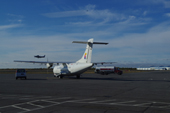 | 1: Cannot Wait to Go!
Today should have been the first day aboard our new home for the next month - the Canadian Coast Guard icebreaker Louis S. St.-Laurent (the Louis). I woke up early in Yellowknife (Northwest Territories Canada), excited and eager to fly north to Kugluktuk and the Arctic Ocean, where a helicopter will deliver us to the Louis. This year, 26 scientists from institutions in the USA, Canada and Japan, will be making measurements from the Arctic Ocean’s Beaufort Gyre. Most of us gathered at the airport, busily checking in metal boxes with supplies for our biological, chemical and physical measurements. | 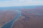 | 2: Finally on Board
Today a drizzle in Yellowknife saw us off and we finally boarded the flight to Kugluktuk. Stepping off the plane, the scenery - vast grassland and hilly terrain - was breathtaking, much wilder than Yellowknife. As I read on the plane, ice fishing, fox trapping and seal hunting would be a central part of a vacation in Kugluktuk. | 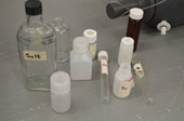 | 3: Heading to the Beaufort Gyre
Today’s daily science meeting indicated the start of the busy preparation for our first station - AG5. We will arrive tomorrow afternoon, where we will take our first CTD measurements and collect Niskin bottle samples. CTD stands for conductivity (which indicates salinity), temperature and depth. These properties allow us to identify unique signatures of water masses in the ocean. For example, the main objective of my research is to study eddies in the Arctic Ocean which can carry water long distances. By analyzing the temperature and salinity properties of the water within the eddy, we can estimate the formation location. Niskin bottles are used to collect water samples from designated depths in the ocean. The analysis of the water will yield its chemical and biological properties such as methane, oxygen, nutrients, barium, etc. | 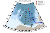 | 4: First Water Samples from the Arctic
This morning we were greeted by a fairly windy and wavy day with light snow. I awoke finding myself hardly able to stand in the swaying motion. The wind reached up to 35 knots around midnight, but fortunately the weather slowly improved before we arrived at our first station for CTD/rosette deployment. | 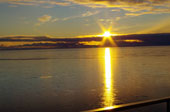 | 5: Ice and a Polar Bear in One Day!
We had been sailing for three days, and except for the chilly winds to remind me where I was, we hadn’t had the chance to experience two unique traits of the Arctic - ice and polar bears. We were lucky to see both of them today! | 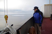 | 6: "Sushi" on Ice
With increasingly dense ice coverage, the Louis began to show her character of an “icebreaker”. Her specially designed hull enables her to propel onto the ice, and break through by gravity to clear a path. The ice is still thin, but Cadet Navigator Geoffery Oliver showed us a video of a similar icebreaker breaking thick ice. The ship’s hull rose up onto the ice, and then dropped down heavily to break the floes. I could imagine that might be the sound and feeling we will experience in a couple of days as we head further into the pack to begin our on-ice work. | 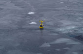 | 7: Day of Recovery!
We had gone through 7 CTD stations by this morning. Everything was according to routine and the workings of the CTD sampling team became smoother and smoother. Just when I thought today would be uneventful as usual; I was extremely excited to learn that several ice buoys would be recovered later today; especially as I have been analyzing data from these systems in my past three years of graduate study. | 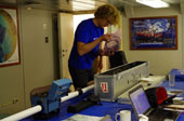 | 8: Life in the Arctic
Today was a day of preparation, since tomorrow would be big excitement - our first on-ice deployment! Several buoys will be installed in an ice floe and ice measurements will also be taken. We completed helicopter safety training several days ago, and all equipment was being assembled and tested for the final time. | 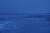 | 9: Radioactivity in the Arctic
Today was supposed to be our first ice station, but low visibility due to snow and fog did not allow for a helicopter recon to hunt for an ice floe as our base. Conditions didn’t improve by the early afternoon, and chief scientist Bill Williams and WHOI team leader Rick Krishfield decided to postpone our ice station until tomorrow. In the extra time we would head to the next rosette station. | 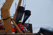 | 10: Zooplankton and a Polar Bear Family
After waking today, the first thing I did was check the weather conditions - I really couldn’t wait to get onto the ice and we were already at the northernmost stations of our original cruise plan. The seas are almost fully ice covered now. Rick, with his rich experience on ice, was out in the helicopter after breakfast to identify an ice floe sufficiently large and strong to support our thousands of pounds of equipment. Before noon, we were all waiting in the helicopter hangar ready to board. | 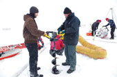 | 11: On Ice!
After our on-ice buoy deployments were postponed for two days due to weather, we finally made it onto the ice today. It was such a fantastic day, and there’s so much to write about! Around noon, after the morning fog lifted, the helicopter began ferrying gear and passengers to the ice floe chosen for the deployment earlier in the day by Rick. I was scheduled to be aboard the third flight, and I couldn’t wait to step on the sea ice for the first time, so I layered myself up right after lunch and waited anxiously in the helicopter hanger. | 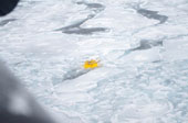 | 12: Recovery of Mooring B
One of the major goals of our expedition is to understand long-term changes in the Beaufort Gyre. In this region, the Arctic Ocean is relatively fresh due to the clockwise atmospheric winds. The strength of this wind forcing controls the accumulation of relatively fresh surface water, as well as its release (when the atmospheric forcing becomes weaker). The large-scale wind forcing not only impacts the salinity and stratification of the Arctic Ocean, but has implications to the entire Arctic ecosystem and global climate. For this reason, the response of the ocean to evolving atmospheric forcing as the sea-ice cover changes requires thorough study. Three to four mooring systems (instruments anchored to the sea-floor, measuring the water column above) have been installed each year since 2003; these measurements of water properties, including salinity (to measure the fresh water) and temperature, have provided us with more than a decade of information. | 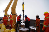 | 13: Re-deployment of Mooring B
Today, we continued with yesterday’s mooring work. After making repairs, changing batteries and testing instruments, we re-deployed Mooring B in the same spot: 150W, 78N, on the northwestern side of the Beaufort Gyre and to the northeast of the Northwind Ridge and Chukchi Borderland region. This region has the most complicated sea-floor topography in the entire Canada Basin region, and related to this are many energetic ocean processes that can be measured by the mooring. I recently submitted a paper with my adviser (Mary-Louise Timmermans) investigating some of these processes (ocean eddies) by analyzing the measurements from Mooring B taken since 2003. Before coming on this expedition, the mooring location was just a latitude and longitude in my head, but now observing the mooring deployment into the deep ocean below, and thinking about the possibility of an eddy slowly passing by felt awesome! | 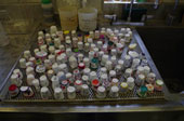 | 14: Life on the Louis
We are now at the northernmost site of our expedition and there is almost no open water around us. I am adjusted now and enjoy the constant shake of the Louis -it gives me a sound sleep especially after a midnight rosette cast. I am lucky to look out at the breathtaking view over the bow of the Louis riding over the ice as I write dispatches in the forward room. So far, we have encountered all types of sea ice, from thin, fragile ice at the beginning of the cruise, to newly formed “pancake” ice (you can easily imagine its shape by this name), and now vast chunks of thicker, older ice. In the path of the Louis, these chunks of ice are broken and flipped over on their sides showing a cross section with snow cover; I will name this “cheesecake” ice. | 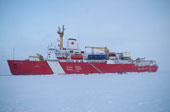 | 15: Ice Based Observatory Number 2
Following rosette casts, we headed north again to begin our second and last ice deployments. At around 80N, it was not long before we found suitable ice for our buoys and ice measurements. We did not even need the helicopter to deliver people to ice; it was a thick multi-year ice floe that the Louis could park beside, and we only needed to walk down some steps that were positioned over the side of the Louis. | 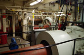 | 16: Engine Room Tour
With the ice station finished, we had a day before arriving at the next station, and today was the perfect time for a tour of the engine room. Would could satisfy our curiosity and finally see the heart of the Louis. | 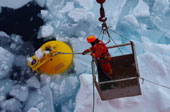 | 17: TU-1 Recovery and Captain's Dinner
The ice became thinner and thinner on our way south. This meant that the Louis could steam faster than through the thicker floes, and we arrived at our mooring recovery location this morning - a couple of hours ahead of schedule. The Tokyo University of Marine Science and Technology (TUMSAT) mooring at this site on the Northwind Ridge (our furthest west station on the map in dispatch 4) was deployed during last year’s cruise. The mooring system has a similar configuration to our BGOS moorings, but it does not include a sediment trap and Remote Access Sampler. |  | 18: Recovery of Mooring A: a View from the Bridge!
This morning we arrived at 75N, 150W for the recovery of Mooring A in the southwestern basin. Now surrounded by open water, we expected the recovery to be much easier with no ice cover to break in preparation for the surfacing of the mooring’s top floatation sphere. | 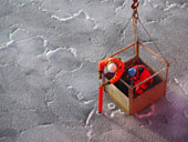 | 19: Heading Back North
After recovering Mooring A, we needed a day for battery changes, other assessments and adjustments of the instruments and data examination before redeployment of this mooring. We took this day to head to the northeast to visit a new station in the central basin. Temperatures are dropping fast now as October progresses. Edward told me that the now-expanding edge of the sea-ice pack can move south at a rate of up to 10 km a day. After lunch, the smiling eyes of the sea-ice group made me realize that we were once again surrounded by sea-ice. | 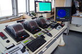 | 20: Mooring A Redeployment and Another Aurora!
After one day of hard work by the WHOI group, Mooring A was ready for another year in the Beaufort Gyre. The preparation for its redeployment began soon after breakfast - instruments and equipment were positioned on the fore deck, and the anchor waited beside the winch. Today I was once again on the bridge to experience a mooring deployment from this perspective. | 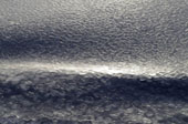 | 21: Colored Dissolved Organic Matter in the Arctic
Our expedition has been going for 3 weeks now and the science activities have been going smoothly as planned. All of the ice buoys have been deployed, and some even have been recovered. Only one mooring is left to be recovered and redeployed in three or four days from now. Water samples are being collected and analyzed in the lab here. The schedule even allows us a chance for some science talks before the daily science meeting. | 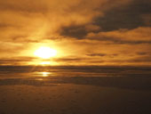 | 22: Water Column Structure in the Canada Basin
Today was my busiest day of the entire cruise - we arrived at the Barrow Line in the Barrow Canyon region along 150W. Due to the complex shelf bathymetry here, and the strong influence from Pacific Ocean inflows, the ocean flows are complicated and we wanted to capture these. This meant we had close station spacing and only about one hour between stations, and I was going non-stop! Investigating the freshwater content change of this region and the physical processes responsible (and how this relates to a decreasing ice cover) is a major goal of this cruise. So it is a good idea for me to introduce the water column structure in the Canada Basin. These are the wiggles in temperature and salinity I examine on the computer screen in the CTD shack as the CTD profiles the water column. | 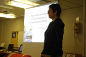 | 23: Arctic Ocean Acidification
With decreasing sea-ice cover, the Arctic Ocean is exposed to the atmosphere more than before, which has a potential influence on sea water properties, especially those of the surface mixed layer. For today’s science talk, Michiyo Yamamoto-Kawai, a geochemist from TUMSAT, presented her work on the interannual variability of surface ocean acidification in the Canada Basin. | 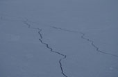 | 24: Mooring D Recovery
Today was our final mooring recovery - Mooring D at 74N, 140W. The recovery started early this morning, around 8 am. Low temperatures of around -13C and the fact that we were in the southeastern basin, where the ice is solid and extensive, meant a challenging day for mooring recovery. After Rick located the mooring position with acoustic triangulation, it took a while for the Louis to steam back and forth to break the sea ice cover around the mooring. With the help of Captain Anthony Potts, First Officer Scott Kelly and Leading Seaman Vince Mullett’s great maneuvering skills, the ice surrounding the mooring was soon reduced to small manageable chunks. Once Rick sent the signal to the acoustic releases to let go of the anchor, we spotted the top floatation sphere almost immediately. | 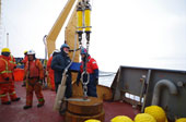 | 25: Mooring D Redeployment in the Company of a Sweet Polar Bear!
Our final mooring operations - redeployment of Mooring D - began as planned after lunch today at 74N, 140W. I went to the fore deck for this one. This mooring includes a Bottom Pressure Recorder (BPR), sediment trap, MicroCAT, McLane Moored Profiler (MMP), Upward Looking Sonar (ULS), Acoustic Doppler Current Profiler (ADCP) and Acoustic Wave and Current Profiler (AWACS). Today was extremely cold, with temperatures dipping below -15C and the wind later became so strong that I could barely remain standing on deck. The wire over the side tilted up to 45 degrees by the time we were nearly ready to release the mooring. Scientist Sarah Zimmerman came all the way up to the fore deck to offer me warmer boots and gloves (she takes good care of us and we adore her!). In spite of the weather, the rich experience of the WHOI team, with many years of mooring operations, made for a successful deployment of the last mooring, together with the perfect workings of the officers on the bridge and all the crew on the fore deck. The top floatation sphere, finally released, and gradually sinking to depth marked the consummation of all the mooring work this year. | 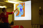 | 26: Ice in the Beaufort Gyre
Along the track of the Louis, I have been fascinated by the many forms and stages of sea ice, from the newly formed pancake ice, to the beautiful nilas, to the older, solid ice cover in which we deployed our Ice-Based Observatories. Now I fully understand and agree with the comment our seaman Bernard Noseworthy made at the beginning of the cruise that he would never get tired of the ice. | 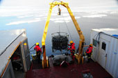 | 27: Last Station
Today marked the last of all our CTD stations and I was lucky to be a part of the final cast. We have taken 70 water-column profiles (casts) during this cruise and a total of 1502 water samples. Unlike the ice stations and mooring deployments and recoveries, CTD/rosette casts have been a non-stop activity - the ship steams from station to station, day and night. We did this with a day watch (Mike Dempsey (Lead), Celine Gueguen, Christopher Charles and me) working from 12 pm to 12 am, and a night watch (Hugh Maclean, Sigrid Salo, Edmand Fok and Jen Reeve) from 12 am to 12 pm. Sarah Zimmerman, as the Data Analyst of the team, was always around to offer help, from assessing strange-looking figures, to problems with the CTD, to helping out with the sampling, and spreading joy with her big smile. The day watch team are the people I interacted most closely with; I felt lucky to be part of this team and fit in almost immediately. I am sure I did complain when we encountered crazily close stations without much time to rest or eat, and about the tension of triggering bottles from my position at the computer, but I enjoyed my work in the rosette lab. I will not forget Sarah considerately covering my job while I stayed on the fore deck in the freezing temperatures for over 4 hours; Mike (like our amiable dad) secretly completed all the labels for me so that I had some rest time while he was working non-stop for the entire day; Celine brought me hot drinks and accompanied me with great conversations and interesting stories; Chris told funny jokes that made the long cast seem shorter; Kenny who was not on our team but always came with his exciting rock music to help us sample ... I would miss all of this when I am home. |  | 28: Packing and Party
We have successfully completed all science activities, with the hard work and collaboration of scientists both on board the Louis and back home. Today would be a packing day to prepare all valuable samples for shipping, and a time to document and summarize all of our work done during the cruise. Scientist Deo Florence Onda made a small movie of some highlights - science activities, polar bears, northern lights, bringing us memories from all the way through. | 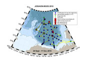 | 29: A Closing Word from the Chief Scientist
We are now steaming east towards Kugluktuk with the west wind on our backs. Our 13th annual science mission is completed successfully, thanks to the Captain and Crew of the Louis and science teams from WHOI, Fisheries and Oceans Canada, and other teams from the USA and Japan. At the end of each expedition we make a map showing our track and science stations along the way (Figure 1). This year there were 4 mooring recoveries, 3 mooring deployments, many buoys deployed in the ice as part of 2 Ice-Based Observatories, 3 buoys opportunistically recovered, 53 XCTDs and 70 CTD/Rosettes. During our 27 days at sea, an enormous 11,717 water bottles were filled with sea water for geochemical analysis from the Niskin bottles on the rosette. With these we will be able to trace waters that flow in the Arctic Ocean, but that originate from elsewhere, from rivers, from the Pacific Ocean and from the Atlantic Ocean. We will also be able to learn more about the structure of the ecosystem in the Beaufort Gyre and how it changes with changing ice cover. |
Last updated: October 7, 2019 |

