 | 1: Starting Out
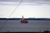
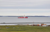
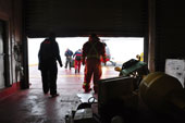
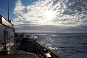
Today has been a flurry of activity as we prepare to set out on this year’s cruise. The new science party and relief crew have all joined our ship and new home, the CCGS Louis S. St-Laurent in Kugluktuk, Nunavut. |
 | 2: All in a Day's Work
There’s nothing like mounting a delicate sensor ten feet out past the front edge of a Canadian ice breaker while steaming through Arctic waters to get an adrenaline rush. Today I worked with Yasuhiro Tanaka, a student from Kitami Institute of Technology and several of the ship’s crew to install this sensor that measures downwelling radiation from the sun and upwelling radiation from the sea surface to learn more about the reflectivity of sea ice. |
 | 3: Science Operations Begin!
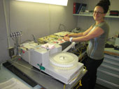
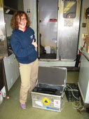
We’ve been on the ship for 3 days now and have almost finished unpacking our boxes and setting up the equipment needed to carry out the science operations for the voyage. A lot of careful planning and preparation in the months before the cruise has ensured that the science group is ready for almost any surprises. Boxes of spare components, duplicates of integral equipment, as well as a lot of extra batteries and duct tape, help to troubleshoot the issues of equipment malfunction, breakage during shipping, and missing odds and ends. As we all unpack, sort, and set up our lab and sampling stations, the whole team is eager to lend a hand to help setup go smoothly. |
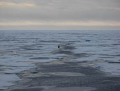
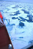
 | 4: The Many Faces of Sea Ice
We hit sea ice last night. It jolted and jostled the ship and made a great grinding sound that woke me up. We’ve been in about 90% ice covered waters since then, and I’ve spent a good part of the day learning to read the ice. |
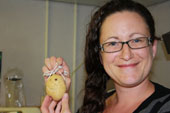 | 5: Mr. Potato Head
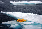
Around 5pm this evening an announcement came over the ship’s intercom: “Attention all ship personnel: If this is your first trip to the arctic, please report to the forward lounge at 8pm sharp.” |
 | 6: Boy-O-Buoy!
Today we had the opportunity to recover some instrumentation that was installed on an ice floe during the 2012 JOIS program. One of the instruments installed in this array is called an O-Buoy, an instrument package that measures atmospheric carbon dioxide, ozone, and other natural atmospheric constituents such bromine oxide. The O-Buoy monitors changes in ozone within the lowest few hundred meters of the atmosphere above the land/ocean - termed the boundary layer. In the spring time when the Polar sun reappears, ozone in the boundary layer can be depleted to near zero, often for days at a time. This ozone depletion is thought to be closely associated with the release of bromine as salts at the sea ice surface, left from the previous winters freeze-up, are exposed to light the following spring. |
 | 7: Tales from the Deep Sea
What would it be like to spend a year deep in the Beaufort Sea? Imagine being anchored to the seafloor but capable of moving up and down in the water column. You’ll feel the pull of ocean currents, taste changes in the saltiness of the water as it fluctuates in height, after a big storm, with the seasons. You’ll find warm layers and cold layers. If you pay close attention you’ll hear when the sea ice thickens and thins; you’ll feel ever so slight changes in pressure as the sea level shifts up or down. By the end of the year, you’ll have lots of stories to tell. |
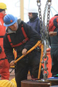 | 8: Mooring D Deployment
The big science activity of the day was the deployment of a new mooring to replace the one recovered yesterday. The total operation took roughly 8 hours, though the actual deployment took only half that - the rest of the time was spent prepping gear and finding just the right spot to deploy the mooring, while still having favourable ice conditions at the surface. |
 | 9: It's Been a Long Time Series...
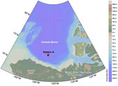
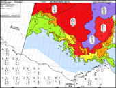
The 2013 Joint Ocean Ice Study (JOIS) expedition will visit over 60 stations in 4 weeks to collect hydrographic and chemistry data throughout the Canada Basin, from the shallow Beaufort Shelf and Northwind Ridge into the deep basin interior. Sea ice and water column observations (such as temperature and salinity) collected during this year’s program will be combined with data collected throughout the Canada Basin since 2002, creating a long-term time series picture of the state of the Arctic Ocean. This massive undertaking has been built gradually from the humble beginnings of Polar expeditions during the late 80’s and early 90’s. Today we collected seawater samples from Station A (72.8N, 144.6W), the longest running time series station in our cruise track. Samples of water column chemistry have been collected at this station since 1989, creating a remarkable time series with which to compare the JOIS program data from 2002 - 2013. Chief Scientist Bill Williams has spent the last 10 years studying the rapid changes in the sea ice and water column of the Arctic Ocean. He explains that without a long term time series to provide a baseline we would not understand the magnitude of the dramatic changes seen in the past decade. |
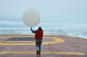
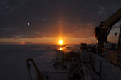
 | 10: Daily Patterns
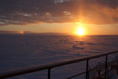
1:00 am - I just woke up for my shift. The sun is low on the horizon, shrouded by thick fog again. It won’t set at this latitude for another couple weeks. Now it almost skims the horizon. Every hour for the next eight hours I’ll walk up to the bridge - the top level of the ship—and make observations of the ice, the melt ponds, the surface topography, and the weather to report back to the International Arctic Research Center. I also am on call to deploy an xctd or to assist Sigrid with her weather balloons. The xctd is a small, expendable sensor in a tube that measures conductivity, temperature, and depth. |
 | 11: See the Sea with the CTD
If you’ve ever known any sea-going oceanographers, there’s a good chance you’ve heard them talk about CTDs, rosettes, and Niskin bottles. These are core tools of the trade for investigating water properties. |
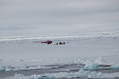
 | 12: Vistors Always Welcome!
This morning the foredeck was a flurry of activity as the BGOS A mooring was recovered. This mooring sits in the south western corner of the deep Canada Basin (75°N, 150°W), at a depth of 3824m. Because of its proximity to the shelf slope, BGOS A is in a good spot to occasionally catch eddies as they come off the shelf into the deep basin. The recovery today was a remarkable success, as well as being incredibly speedy (3.5hrs!), 100% of the instruments were collected unharmed and found to be fully operational after the 1 year deployment. The WHOI Mooring team looked rosy cheeked and quite satisfied after such a flawless recovery! |
 | 13: Polar Bears, Tea Leaves, and Arctic Ocean Oscillations
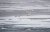
After yesterday’s recovery of mooring A, we steamed north to a sampling station in the late hours of the night. At 4:00 am on the return trip back to the mooring station, Roy Spracklin, the quartermaster at the wheel, called out in his characteristically calm voice, ‘three polar bears up ahead’. |
 | 14: Detour to Barrow
We can feel very isolated out here at sea. It’s much easier to stay in touch with our families and friends these days with satellite internet and phones now available on ships, but sometimes it’s easy to forget that the rest of the world is chugging along while we’re out here. |
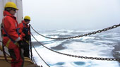 | 15: An Evening on the Wire...
As watch standers we spend a large chunk of each day out on deck while the CTD-Rosette is descending/ascending through the water column. Part of our job is to make sure there the cable pathway is clear and that there is no ice creeping toward the rosette line. Although there are a few ways we can adjust the position of the cable to get it out of the way of approaching ice, by far the most effective is the ships bubbler system, which works by pumping air bubbles from below the water line. With a power thrust of 1.2 megawatts, water and air are pushed up from below the ship, lubricating the hull and pushing ice away from the vessel. The Louis has three different discharges between the bow and mid-ship, and they can be used as bow thrusters, to move ice, and to help dock the ship. The ships bubbler system is one of the primary tools to allow us to carry out CTD-Rosette casts in the Canada Basin’s ice covered waters. Not only is it one of the most efficient ways to clear the area of ice before deploying the rosette, but it also helps to keep the area clear of ice when we recover it again after sampling. |
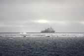
 | 16: Cold at Last
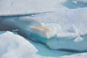
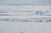
Until yesterday, dense fog rolled in each night and stayed until late in the morning. It blocked the sunlight, giving a pretense that the sun had set. When I climbed up to the bridge this morning at 2am for an ice observation, the windows were still painted gray. As the morning wore on, the blanket of fog lifted into low clouds which misted snow. At the same time, we entered the largest ice floe we’ve seen yet. A floe is a continuous piece of sea ice that has formed in the water. It was young and thin, maybe 10 centimeters, but it stretched out in all directions of the ship so far that we couldn’t see the ends. The surface of the floe was spotted like the coat of a Dalmatian: a 2000+ meter white ice sheet melted in round spots of transparent ice, revealing the dark ocean beneath. |
 | 17: Furthest West
After recovering the first TUMSAT mooring yesterday, we continued to steam west to the Chukchi Abyssal Plain to pick up the second today. These moorings were deployed last year in collaboration with the WHOI group, and it will be interesting to see how they complement those in the Canada Basin. |
 | 18: The In-Between Time...
Yesterday we had our furthest-west achievement and recovered the last mooring along the Northwind Ridge (77°N, 170°W). Since then we’ve spent quite some time in transit on our way back into deep waters. During our last few days in the northwest corner of the Canada Basin we’ve experienced thicker and more continuous sea ice conditions, slowing our progress but giving some beautiful seascapes. It has been a nice change to see so much more ice and much less fog. We’ve also had some bear visitors to the ship! This morning a mother bear and her two cubs came within view of the ship around ~78°N, ~160°W. Then later this afternoon we saw a large bear, likely male, out on his own lumbering through the ridges (~78°N, ~155°W). It is amazing to think these bears can survive all the way out here. |
 | 19: The Heavy Ice Pack
Until yesterday, the ship used just two of its six engines to get through the ice. Now we’re using four, and the bubbler which blows pressurized air out through holes on the sides of the hull so the ice doesn’t stick. We’ve entered heavy ice pack. |
 | 20: Time for Shrinky Cups!
Well we’ve done it - we reached our most northerly station called CB11. We arrived at 79oN, 150oW at 2am to find nice ice floes, and chill temperatures. This is the first station where we saw freeze up conditions, with thin skins of ice and slush forming on the water surface. |
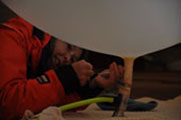
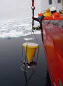
 | 21: ITP
It was a beautiful day to be on the Arctic Ocean - the fog lifted, the clouds parted, and we even had some blue sky! The sunny afternoon also made it a great day to deploy the first Ice Tethered Profiler (ITP) of this year’s program. The ITP is an autonomous package of sensors fixed to an ice floe. It provides continuous observations of the water below the ice as the floe drifts around in the Beaufort Gyre. |
 | 22: Preparing to Walk on Water
Years ago the lead scientists began planning a project to study the dynamics and physics of the Beaufort Gyre. Months ago the team was preparing for this year’s expedition - planning, packing, pushing paperwork, organizing logistics, preparing equipment. Weeks ago we boarded the ship, unpacked gear, discussed ice-based operations, and began the deck-based work with the CTD and mooring recoveries and deployments. Yesterday we made final preparations to fly out onto the sea ice to collect ice cores, take measurements, and install an ice-based observatory. |
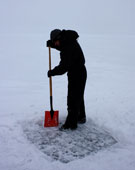 | 23: Ice is Nice
Today was the largest and longest scheduled day of ice work. We not only deployed an Ice Tethered Profiler, but also a wave buoy, the O-Buoy, an Ice Mass Balance Buoy, an Ice Tethered Micro mooring, an Arctic Ocean Flux buoy, and 4 GPS buoys. As this was happening, we had teams taking ice cores for measuring thickness, temperature, salinity, density, iron, and microbial communities. The whole operation, from reconnaissance flight to wrap up was just shy of 12 hours. Things were a little hairy at the beginning, with some uncertainty about the weather: fog was threatening to move in, and it was snowing for a couple of hours in the morning. All told it was pretty nice working conditions in the end - a persistent cloud cover kept the glare off the ice and snow minimized and it wasn’t too cold out. The members of the ice party were all glad to get back to the ship at the end of the day, all looking a bit rosy cheeked and windswept. |
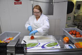
 | 24: Nutrients in the Canada Basin
We are travelling on the shelf break to Prince Patrick Island today. The ice has been heavy and the Louis keeps bumping along through the ice. Tomorrow there will be two, maybe three more stations worth of test tubes waiting in the refrigerator for nutrient analysis. The heavy ice, which causes much bumping and vibration, adds to the challenges of analysing samples on sensitive instruments in the labs. |
 | 25: Another Day on the Ice
While air temperatures descended to negative eight degrees Celsius this morning, we arranged thousands of pounds of gear in the helicopter hangar, warmed up the small motors that were coming out onto the ice with us, and started layering up. This was our second and final day of ice sampling, and the last installment of an ice-based observatory (IBO) for the JOIS 2013 expedition. |
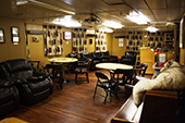 | 26: Carpentry at Sea
There is a common design element that I have come to expect on the ships that I sail on: metal sheeting painted tan, beige, or off-white. The Louis is a different story. There is woodwork all over the ship, which immediately gives the ship a very different feel - a very cozy one in my opinion. |
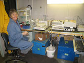
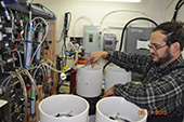 | 27: Radon in the Ocean's basement
One group from the URI Graduate School of Oceanography is measuring radon-222 to estimate how gas passes between the ocean and the atmosphere, with sea ice in the way. Here is that story. |
 | 28: Wrapping Up
As we approach the end of our cruise, we’re also steaming through the heaviest ice pack yet. Last night, with all five engines running, we had to go off course to steer around impassable ridges. I woke a few times to the jostle and jolt of the ship as the ice tossed us back and forth. It feels nothing like the rhythmic rolling of waves in the ocean. Ice causes the ship to move unpredictably, in jerks and sways. It’s marvelous. Sometimes we feel the bow ride up on a ridge and come to a stop. Then, slowly, we back up and come at the ice again. Usually the first pass weakens the ice enough that we crack through on the second pass. Sometimes not, and we find a different, thinner route. |
 | 29: Last Push for Science
It's over! The science days are finished! We wrapped up our sampling with a high intensity transect from the basin up onto the Mackenzie Shelf. The bathymetry shallows quickly in the area, so we have stations spaced closely together. This means that we arrive at the next station before weã¢â€â™re finished sampling the last one, and have to put the rosette straight back in the water as soon as the sampling is wrapped up. Days like these pass very quickly, but it felt very good at the end of the day to bring the rosette back on deck for the last time this year. Smiles all around. |
 | 30: and That's a Wrap!
With our final sampling station finishing up last evening around 11pm, the science team has switched gears and spent the entire day packing up, cleaning, and dismantling the equipment we’ve been using these past 5 weeks. It is amazing to be reminded of how bare the lab spaces were before our boxes were unpacked at the start of the program. |
 | 31: A Closing Note from the Chief Scientist
We are now just offshore of Kugluktuk and in the midst of a gale: 35kt winds. These are the first strong winds we have had and I hope they blow through before we disembark tomorrow. |

