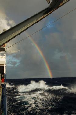
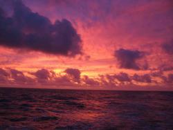
Angie PendergrassToday is the second hot day in a row. The air temperature is 24.7 C, and the wind is only 1 knot. Overhead there is stratocumulus, as most days, with the sun poking through breaks in the clouds. The sea is extremely flat. There are absolutely no whitecaps in view. It feels like we're on a really, really big lake; a lake that is 2904 m deep and indigo in color. The last few days (I can't keep track of how many) have been calm, but not quite this calm. Winds are often around 10 kts, with some swell and a few white caps here and there, and clouds that vary from grey stratus to broken stratocumulus. There have been a few good sunsets, where the clouds turn from grey to bright yellow and orange and then pink. One day started with a sky full of fair weather cumulus at noon (the sky is a field of small, low, puffy clouds), which grew throughout the afternoon until at sunset they were cumulonimbus (raining cumulus clouds). At sunset, we were transiting (driving eastward) into one of these cumulonimbi, which gave us a brilliant full rainbow with a hint of a second. We are in a very isolated stretch of sea (our position as I write is 32.5 S, 122 W). The nearest islands are the Pitcairns, which the Captain says are barren and we would not bother diverting to if anything were to happen because they are so undeveloped. And they're not that close anyway. The chief scientist reported yesterday that we are 16 degrees of latitude north of the Pole of Inaccesibility, which is the place on the planet farthest from any land. The next island we will come near is Easter Island (Ile de Pacques in Spanish, since it's owned by Chile, but Rapa Nui in Polynesian). But we'll only come as close as 5 degrees of latitude (300 nm) from it, which is a long way at our steaming speed of 12 kts. Near the end of the cruise (80 W), we'll pass 60 nm from the Juan Fernandez islands of Chile, which includes Robinson Crusoe island. These are mainly nature preserves, but my Chile guidebook says they are worth visiting. But at that point, we're practically to South America. Since we are so far from land, it should not be surprising that all of the wildlife that I am aware we have seen fits easily in one paragraph. Despite the persistent efforts of many to fish, we have only managed to catch two mahi mahi so far. As we climb the East Pacific Rise with all of its seamounts, we are hoping to reel in some more, but no luck yet. In terms of sightings, there are similarly few to report. There were four birds floating around the boat a week or so ago. We expect to find a few fish attracted to the lights we shine at night for deployment and recovery. Last night, we saw 5 small fish. The night before that, there was a squid and two flying fish, and the night before that another flying fish. (Flying fish are great; they look like airplanes or butterflies and are bright blue.) Last updated: January 21, 2010 | ||||||||||||||||||
Copyright ©2007 Woods Hole Oceanographic Institution, All Rights Reserved, Privacy Policy. | ||||||||||||||||||