Please note: You are viewing
the unstyled version of this website. Either your browser does not support CSS
(cascading style sheets) or it has been disabled. Skip
navigation.


John KempAugust 23-25, 2004
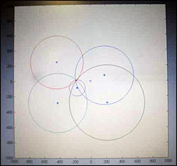
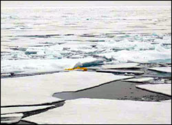
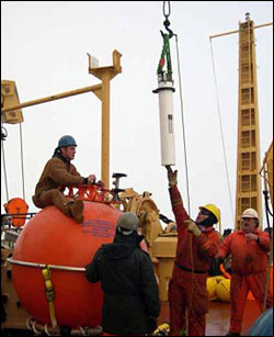
From the initial looks at the satellite ice charts when we first came onboard the LSSL, all of us realized that mooring C had the heaviest concentration of ice and would probably be the most challenging mooring to recover. Our initial suspicions proved to be correct. When I first opened my shade at 0530 the morning of the recovery, I quickly realized two things: the first being that it was very foggy which had been the case for all our mooring operations, and the second being that it was going to be a long day due to the heavy concentration of ice and lack of open water. The ship had spent the early morning hours traversing back and forth over the mooring site breaking up the large ice floes into smaller pieces, in order to reduce the risk of the surface float getting stuck under a large floe once it was released. After breakfast, The Captain, Chief scientist Sarah Zimmermann, Rick Krishfield and I met on the bridge to discuss our options as it was apparent to everyone that the ice conditions that morning were too heavy to attempt a recovery. The decision was made to steam up current of our drift track to search for a lead or open water that might, by chance, drift over the mooring site. A small patch of open water was spotted about ½ nautical mile away from the mooring site, which hopefully would drift over or near the moorings position in a few hours and allow us to release the mooring. We took advantage of the down time by getting additional acoustic ranges to a transponder on the subsurface buoy from the ship to pinpoint the exact location of the mooring. It was mid afternoon, when Sarah, Rick and I were on the bridge discussing alternative plans from A to Z when the Captain voiced, "It's now or never". Everyone quickly made their way down to the deck to get ready. The Captain maneuvered the ship in such a fashion that a small pond opened up over our calculated survey position (Best Estimate). The second mate radioed down to release it. The release command was sent multiple times and finally a reply from the acoustic release that it had received the command and was releasing. Within seconds the deck crew spotted the orange buoy just off the bow. It surfaced just where everyone thought the mooring to be! The recovery was going smoothly until we encountered a major wuzzle (tangle) just near the end of the wire supporting the moored profiler. Fortunately the moored profiler was not damaged and was brought aboard and the remainder of the mooring was hauled in. The WHOI-C mooring was recovered in 2-1/2 hours. Saturday Aug. 21st The WHOI team spent the day getting the new mooring prepared and dumping data from the recovered instrumentation. Some of us even snuck in a traditional afternoon nap. Sunday Aug. 22nd The last mooring deployment went very smoothly. The total deployment time was just under 3-1/2 hours. Handshakes and thank you's to the deck crew came next. We are all extremely pleased to have had their assistance and expertise working with us on deck.
Last updated: October 7, 2019 | ||||||||||||||||||
Copyright ©2007 Woods Hole Oceanographic Institution, All Rights Reserved, Privacy Policy. | ||||||||||||||||||