Please note: You are viewing
the unstyled version of this website. Either your browser does not support CSS
(cascading style sheets) or it has been disabled. Skip
navigation.


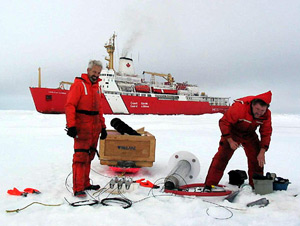
Andrey ProshutinskyAugust 22-23, 2003Numerous observations in the Arctic Ocean are needed to understand its dynamics, interactions with the atmospheric and cryospheric processes and to detect climate change signals. For these purposes, scientists use different instruments, some of which were already discussed in our previous dispatches (CTD, moorings, Bongo nets). Today’s dispatch is about ice buoys mounted on the drifting ice. Sometimes, these systems carry arrays of instruments attached to a wire or cable beneath the sea ice surface. On August 22, we recovered a JAMSTEC Compact Arctic Drifter (J-CAD) deployed by JAMSTEC’s scientists during JWACS 2002. J-CAD is an inexpensive state-of-the-art compact buoy designed and developed by JAMSTEC and METOCEAN Data Systems Ltd for Arctic observations. J-CAD uses the latest technologies and incorporates the vast amount of engineering knowledge and experienced gained from the Ice Ocean Environmental Buoy (IOEB), which was a joint WHOI (Woods Hole Oceanographic Institution) and JAMSTEC program of the 1990s. The J-CAD buoy system monitors the buoy (ice) drift and acquires data from meteorological (air temperature, atmospheric pressure, wind speed and direction) and oceanographic sensors (water temperature, conductivity, and currents). All data are transmitted to JAMSTEC’s computer via satellite. In total, search and recovery operations to retrieve the present J-CAD took about 10 hours. The next day, we deployed a very simple expendable sea ice buoy. This buoy will measure only water temperature and salinity in the upper 50 meters of the ocean at several discrete depths. Four of these buoys will acquire information about fresh water content in the upper layers of the Beaufort Gyre, in combination with the three moorings (discussed earlier) that will collect information about freshwater content of the ocean from 50 meters to the bottom. Data from both systems will be used to analyze seasonal variability of freshwater and heat content in the Beaufort Gyre. Another buoy that was also deployed on August 23rd, is the U.S. Army Cold Regions Research Engineering Laboratory (CRREL) mass balance buoy. Instruments on this system will measure several atmospheric parameters and variability of sea ice thickness and for several years, and will transmit this information to CRREL through satellite systems. The photographs below show different stages of the buoy recoveries and deployments. Last updated: October 7, 2019 | |||||||||||||||||
Copyright ©2007 Woods Hole Oceanographic Institution, All Rights Reserved, Privacy Policy. | |||||||||||||||||