Please note: You are viewing
the unstyled version of this website. Either your browser does not support CSS
(cascading style sheets) or it has been disabled. Skip
navigation.


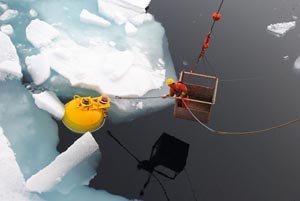
Dr. Mary-Louise TimmermansAugust 11, 2011Heavy ice and fog greeted us at the site of Beaufort Gyre Observing System Mooring D today. Rick Krishfield’s acoustic triangulation to find the mooring, while Third Officer Marian Punch maneuvered the ship in ovals around its last known location, took a few minutes longer than usual - possibly because chunks of ice were interfering with the transducer mounted in the ship’s hull. Once the mooring location was pinpointed (140 m north from where it was released from the ship last October), Captain McNeill and the officers on the bridge broke ice into smaller pieces in the vicinity of the mooring to ensure a safe recovery, unhindered by large ice floes. After Seaman Barney Noseworthy had hooked the top float (from his usual place in the basket) it took less than 4 hours for the WHOI mooring team (John Kemp, Rick Krishfield, Jeff Pietro and Steve Lambert) and the Deck Department to bring all the mooring components on board. The instruments on the upper 2000 m of Mooring D are the same as those on BGOS moorings A and B. On the deep section, a set of sixteen stationary instruments clamped to the mooring wire (spaced every 10 m to every few tens of meters) span the water column, between 2 and 3.5 km below the surface, to measure temperature, salinity, pressure and currents. Unfastening two of these instruments from the mooring line posed a challenge to John Kemp (WHOI) and Boatswain Rico Amamio at the rail because the screws on the instrument clamps were galled. It took only a few minutes with a portable band saw for John and Rico to cut the instrument clamps from the mooring so the recovery could proceed. Last updated: October 7, 2019 | |||||||||||||||||
Copyright ©2007 Woods Hole Oceanographic Institution, All Rights Reserved, Privacy Policy. | |||||||||||||||||