How do you Measure an Ocean Part One: Convection and the Crouton Count by Dallas Murphy
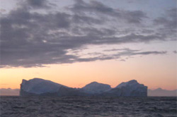
“One of the reasons oceanography has flavor all its own As we said in an earlier dispatch, all oceans of the world are laced with currents flowing on the surface and in the abyss. Centuries ago, mariners recognized the existence of permanent surface currents in the open ocean, and that they were driven by wind. Mariners had no way of knowing—or reason for caring—that there were also deep currents. Only drowned sailors went down there. However, oceanographers can’t be said to understand the ocean if their knowledge is limited to the layer of water at the surface. Please note that “surface currents” extend their influence far beneath the surface, in some cases, such as the Gulf Stream, more than 500 meters. But there are still much deeper currents flowing through the oceans. How did they get there? Why do they flow, since no wind riffles the abyss? In 1751, a slave-ship captain, Henry Ellis, becalmed in the tropics off the bulge of Africa, where his dirty business was conducted, decided to lower a bucket on a mile-long line and pull up some deep water. To his surprise, the water was cold. He and his crew took cool showers, “vastly agreeable,” he wrote, “in this burning climate.” (The slaves didn’t get showers.) He reported this ashore, and scientists wondered why the deep water was cold, when the surface water was so hot? Where did the deep water come from? Well, it could only have come from the polar regions. It must have seeped along the bottom toward the equator beneath the warm surface water. That made basic sense. Everyone knew that cold water was heavier than warm water. It was sort of like vinegar-and-oil salad dressing before you shake it up. The heavier oil sinks to the bottom, and the vinegar rides on top in a distinct layer. Then, in the 1770s, this bright but disreputable fellow named Benjamin Thompson enters the story. Discovering that he was a British spy during the American Revolution, his neighbors in Rumford, New Hampshire (now Concord) were coming to tar-and-feather him. But he beat it out the back way in the nick of time, abandoning his wife and child. He went to England, and then he got a job as minister of war for a duke in Bavaria, Germany. There he invented the crouton to add some bulk to the soldiers’ watery soup and, and he popularized the potato in Europe by serving it to the troops. The job came with a title, so as a sarcastic gesture at his ex-neighbors in New Hampshire, he called himself Count von Rumford. In 1779, the count applied himself to the question of how cold water came to underlie warm water in the tropics. Chemists, who had been analyzing buckets of deep water, were finding a lot of oxygen. Well, the only place deep water could have acquired oxygen was at the surface. And since fish and other marine organisms that breathed oxygen did not use it all up, that must mean that water, once on the surface, must have sunk into the deep. So, the crouton count concluded this: Warm water flows northward from the equator toward the Poles, as for instance in the Gulf Stream. When it reaches the Arctic (to speak of the Northern Hemisphere), the water is chilled by the air. Cold water is heavier—“denser,” in scientific language—than warm water, so it sinks. But since it can sink no deeper than the bottom, it must then spread toward the equator. As it does so, it wedges less dense layers of water to the surface, where they are warmed by the sun. Once at the surface the warm water again flows poleward, where it is again chilled and sinks. So we have a perpetual process—warm water flowing north (and south) into cold regions, where, chilled, it sinks, and so forth around and around. This sinking process is called convection. The count did not discover convection, nor was he first to observe it. Cooks since the dawn of pots would have noticed convective activity in their boiling soup. The Franklin stove works on the same principle, and so do those ugly lava lamps your grandfathers might still own. But Rumford was the first to apply the principle to the ocean. It made sense, a system of convective circulation; it explained the warm and cold layers. The trouble was there was no way to test the theory in the real world. There things stood for centuries waiting for some kind of instrument that could actually measure the circulation in the deep ocean. Scientists suspected that something more complex was going on down there, but they remained ignorant for want of measuring tools. They needed an electronic instrument that they could sink in the ocean and leave for a time while it collects and reports data. There was no such thing until after World War II. Let’s us leave it there for today, with “step one,” that broad concept of convection. (We’re about to have a fire drill.) Tomorrow we’ll talk about the modern arrival of those instruments—and about just what and how they measure in the dark depths of the ocean. That will soon lead us to the specific objectives of this expedition. Tunup sineriassua qanillillugu by Nick MøllerTitarniusaq sanimukartoq 66° ammukartorlu 30° missaani misissuinerput ingerlapparput, Tunup sinerassuanut qanippugut qaqqarsuit portusuut aputitarasaartut arlaatigullu sermersuup aniaffia takusinnaasarparput. Sila silaannareqaaq ullup ingerlanerani seqineq kiisameerluni alakkarteramitigut, pinngortitarsuaq takornartaq seqerlugu. Immami iluliarsuit nunamut qanipput, ataasiakkaat nunamiit ungasillisimasarlutik. Iluliarsuit angissutsimikkut tupiginarsinnaasumik angissuseqarput, paasisat ilikkakkallu naapertorlugit iluliarsuit qulinngiluararterutaat immap iluaniittarpoq, tassa imaappoq iluliarsuaq tamaat takorluussagaanni mikisuarannguaq kisimi immap qaavaniittoq takusinnaasaraparput. Piffiit ataasiakkaat sinerissami sermip aniaffigisartagaai km-iiterinik arlalinnik isoartussuseqarput, sermertut taasartagarput tassavoq aput, ukiut 10.000. tikillugit pisoqaassusilik. Sermersuarmut aput nakkaasartoq ikorpassuillu ingerlanerini nutaamik apummik qallerneqartuartilluni, itisuumut nanertuussaasutullusooq pissuseqarluni itisuumut pisarpoq, tassanngaanniit sanimut sinerissap immallu tungaanut ajattartittutut pineqarluni anillakkiartortarpoq, ukiullu arlalissuit ingerlareeraangata imaanut avalattarluni. Sermersuup silinnerpaaffiani aput nakkaasartoq km-iterit marluk missiliorlugit imal. annerusumik minnerusumilluunniit silissuseqartarpoq, itinerusumi naqitsineq sakkortuujuvoq allaallumi aput ikiorpassuit ingerlanerini imaanut tissukaakkaangami sermitut pissuseqartarluni. Tamannaagunavipporlu aput ukiorpassuit ingerlanerani katersuunnikoq, naqitsinermillu sakkortuumik nanertorneqarsimareerluni serminnguulluni, iluliarsuannguulluni imaanut avalattartoq. Tunup sineria qanilliartortillugu ilisimatuut takusinnaavaat, imap tarajoqassusia allanngoriartortoq taamatullu kiassiut aamma allanngoriartorluni. Sermip iigartartut ungasinngisaani imartaq misissuiffigivarput, tamatumap eqqaani kangerloqarpoq sermersuup iniaffigilluartagaanik. Tupinnanngilaq immap tarajoqassusia maani annikinnerummat aammalu immap kissassusa appangaatsiarluni, misissuinitsinnimi itisuumi kiassiut 0 ataallugu issimasarpoq. Sineriammut qanilleqqaarnitsinni maluginiakkama ilagaat immap qalipaata, piffinni allani takusartagara imaq amerlanertigut taartumik tungujortarpoq, tamanna naliginnaasorivarput. Kisiannimi sumik pissuteqarnersumik maani imartaq qorsorpaluppoq, naliginnaasumimmi imaq qalipaateqanngilaq, piffinnilu assigiinngitsuni immap qalipaataa allanngorarsinnaasarpoq, tamatigulli piffimmiit allamit qalipaammik nuuffugineqartarluni. Assersuutigalugu taasinnaavara immap qalipaataa tungujukkajummat, tamanna qilaap qalipaataanik immamut nuussisutut illuni qalipaatinititsisarpoq. Iluliarsuagissaarmat ullup ilaa aneerujoortilluta sineriassuaq isiginnaarlugu, nalaatsornikkut iluliarsuaq qaninnerpaaq ulikarmat tamatta tupattutut pissusilerluta tupigusuppugut. Qujanartumik ungasiaratsigut uagutsinnut ulorianartorsiornanngitsumik ulikarpoq, assut nuna allamiut tupigusupput uangattaarlumi tupigusoqataavunga. Iluliarsuaq portusuujuvoq angissutsimigut annertulluni, kusarnartorsuuvoq takullugu aammalu illuatungaatigut qiijaamminarsinnaalluni taamak ingitigisorsuaq nammineerluni piriataarmat. Ullormut pisut taakkuupput ullumikkut nalunaarutigisinnaasakka, ulluni tulliuttuni allagaqarfigeqqikkumaarpassi paasisagut susoqarneranillu nalunaaruteqarlunga. Last updated: October 17, 2008 | |||||||||||||||||||
Copyright ©2007 Woods Hole Oceanographic Institution, All Rights Reserved, Privacy Policy. | |||||||||||||||||||