The Warning by Dallas Murphy
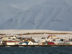
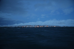
“URGENT: Please pay attention to coming strong storm--low with winds of hurricane force, and we recommend you stay out of the area between 19W and 26W and if possible seek shelter.” This is a direct quote from the Danish Meteorological Institute forecast that arrived aboard Knorr at 0800 yesterday GMT (that’s five hours earlier than in New York). “Urgent” and phrases such as “hurricane force” and “seek shelter” tend to get mariners’ attention. The report predicted 60-70-knot winds, higher along the barrier, for today, Oct. 23, producing 30-foot seas. We have aboard a wave-prediction model that calculates wave height based on wind velocity, duration, and fetch (the three factors determining sea state); for this storm the wave heights soared off the chart at 50 feet. The storm is predicted to increase in intensity today. When we received that threatening forecast, we were situated near the worst sector of the storm. Then the weather map arrived by fax. Few aboard had ever seen anything like it. The isobars along the Greenland coast were so tightly packed they looked like a fingerprint. On weather maps, the symbol for wind velocity is an arrow with a certain number of feathers, each feather representing 10 knots of wind—up to 50 knots. Beyond that point, instead of feathers, a nasty black triangle appears. These wind arrows showed a black triangle plus two and one half feathers. That’s 75 knots, well above hurricane velocity, implying gusts in the 90s. The final decision about everything is up to the Captain, but he and Dr. Bob have a mutually respectful working relationship, and so off they went to confer. The question at hand was, how long could work reasonably continue? One alternative was to hove-to and ride it out, as we did during that big storm early in the trip (see post “The Angry Irminger”) and when it passed, get back to work. But this storm was a different sort of beast. Not only were the predicted velocities considerably higher, but it was supposed to blow for over 50 hours. Knorr is capable of riding out such a blow—and she would have had to if shelter was nowhere available—but she would incur a heavy beating along with her people. Things would break, “come adrift,” in nautical lingo. Given that the storm was to be so powerful and so prolonged, and considering that the north coast of Iceland lay twelve hours away, the only sensible alternative was to seek shelter. We discontinued operations about 4:00 pm (1600) last night and laid a southerly course for a deep crack in northern Iceland called Eyafjordur Fjord. Early this morning, Second Mate Derek, who had the “graveyard watch,” deftly piloted Knorr into the fjord through limited visibility in snow and darkness, positioning her behind a picturesque little island called Hrisey, where high snowy mountains flanked the fjord. And here we shall remain through today (Thursday) and Friday and at least some of Saturday until the beast rages on eastward. And this, too, is an example of how ocean science works and of how, sometimes, nature puts a stop to the work. Dr. Bob is not exactly sanguine about it, but he’s seen a lot of high-latitude seas. He shrugs and says this has happened before, and it will happen again. Remember in the October 21 post we said that when wind blows over water, the resulting transport of the water bends 90 degrees to the right of the wind direction in the Northern Hemisphere? One of the things Dr. Bob and his graduate student Kjetil are exploring on this trip is what happens to the East Greenland Current, when the strong southward barrier winds blow. According to the principle of “Ekman transport,” the water must bend rightward. But it can’t go far, of course, because Greenland is in the way. So what must it do? Well, it must sink. What happens afterward is not entirely clear. Dr. Bob is also interested in another segment of the circulation in this confusingly complex region. His Icelandic colleagues believe that they have found a current flowing next to Iceland into the Denmark Strait that has not been measured before. If it’s there, then it must in some manner affect the regional pattern of circulation. But how? And where did the water come from? That, too, remains unclear. Here’s the point for us: The ocean changes constantly in the short term and longer term. You can’t measure a current once, twice, even three times, and then claim without a doubt to understand it. Because scientists are as human as the rest of us, the temptation must be great to say—after laying on an expedition that brings a ship way up here at a cost of about US$30,000 per day—“now I have it, yes, here’s what’s going on in the Denmark Strait/Irminger Sea,” when all you really have is merely a “snapshot” of the current structure. Dr. Bob, of course, is far too experienced and professional to fall into that trap. And that brings us back to the storm we’re sensibly hiding from. Dr. Bob and his science party have collected a lot of data on this cruise, and in the way of science, the data opens other questions, not all of which can be answered before we return to the “beach.” He’s already thinking about what he wants to measure next year. Maybe, when the beast goes away, he’ll be able to make up some of the time he’s losing, maybe not. But that’s the way it goes with ocean science. Sometimes the ocean is warm and giving, and other times it slams the door in your face. And then, of course, there is this other irony: Part of the objective of this cruise is to measure the atmospheric conditions during storms and, by extension, their impact on the ocean. Well, we have a storm, all right; trouble is, it’s too powerful to allow us to measure it. Island-p kangerluani by Nick M?llerEyja fjord taamak ateqarpoq kangerluk oqquusimaarfipput, illoqarfeeqqat maanngaanniit takusinnaasagut pingasuupput, pingasuniit marluk atersivakka ateqartut; Dalvik aamma Hrisey ajoraluartumilli pingajuata atia pissarsiarinngitsoorpara. Island-imi nunaqarfeerannguit arlaliupput amerlassusaat aalaakkaasoq naluara, talittarfeqanngimmallu umiarsuatinnut naleqquttumik taligata nunat akornanni akileriit uningalluta. Umiarsuup sulisui angalanerput ingerlanngikkaluartoq naliginnaasumik suliassatik nakkutigivaat, ullumilu umiarsuup qaavani sulisoq ”Kyle” suliaqatoq alapernaaffigivara. Suliassat annertunngitsut, iluarsisassat annikiginarsinnaasut umiarsuarmi inuttat suliarivaat. Kyle-p umiarsuup silaannarissarfiisa silammut supiffii imermik ussissatai ilaatigut nutaanngilillutik siggissimasut, nutaanik qularnaaqusersorpai. Oqaatigaalu una angalaneq naammasseriarpat USA-mut uterunik umiarsuaq tamakkiisumik misissorneqassasoq nalilersoneqarlunilu. Atuleqqinnaraniit umiarsuaq ulloq manna tikillugu ukiunik 40 missarluinnaanik pisoqaassuseqarpoq, taamaakkaluartoq nakkutigineqarluartarnermigut umiarsuaq ilusimigut najoruminassutsimigullu taamak nutaanngippasitiginngilaq. Unnugu anori qimaaffipput pissatinnerpaaffimmini 80 km/t atorlugu sakkortussuseqqartussaavoq, qujanartumilli maanga kangerlummut saperngujartoratta, taamaasillunga Island-p nunataa aammalu illoqarfeerartanngui isinnik takuakka. Aqaguagulu sila atoruminarseriarpat iligagineqartutuut angalanerput aallarteqqissavarput, massakkorpiarlu aaliangiusimaneqanngilaq maanngaanniit sumut ingerlaqqissanerluta. Piffissaqangaanngilagummi annerusumik ungasissumullu angalalluta misissuinissatinnik, neriuppungalu aqagu tamanna paasinarsiumaartoq. Ullumikkumiit sapaatip akunnera qaangiuppat Keykjavik-imut utertussaassaagut, umiarsuarlu Keykjavik-miit USA-mut angerlartussaassalluni. Ilisimatuut Keykjavik-mi ullut sisamat tallimat unnueriarlutik aatsaat ingerlaqqittussaassapput, uangali ulloq taanna tikikkutta ullukkut ingerlaannarlunga qallunaat nunaanut ingerlaqqittussaassallunga. Kangerlummi pinngortitaq illoqarfeeqqallu qimerloorujoortillugit, assut pinngortitarsuaq pikkugiummerpara. Qaqqaqarpoq portusuunik qaqqaailu apisimagamik nunataalumi isigisaq tamarmi qaqqoriinnaavoq, Kalaallit nunaanisulli ukioorpalaqaaq pinngortitarsuullu nanarput arlaatigut assut eqqaasippa. Nunaqarfittanngui anginngitsut arlaatigut juulerpalaartumik isikkoqarput, immaqa juulli qanillileriarmat nunalu aputilik isigileriaratigu ”Kyle” oqarpoq juullerpalugalugu, tamannalu isumaqatigilluinnarpara, qaammatimmi tullia nappat juullip qaammata aallartissaaq. Nunaqarfiit uumasuuteqarfiullutillu aalisartoqarfiorpasipput, ullumi qinnguartarninni kangiatungitinni nersussuit amerlasuut takusinnaavakka, kitaatungitinnilu angallat aalisariut avalattoq isigisinnaallugu. Ilimaginngeqaaralu aalisariarluni avalattoq, unnugumi anorersuaq takkusimaartussaavoq, naluarali sullini avalannersoq immaqa talittarfimminut utertoq. Illoqarfeerannguit ukiuulluartarsimagamik Dalvik-mi sisorarluni majuartaataagunaavissoq erserpoq, portunngilarlu ilimanarluni ukiuunerani innuttaasut atorluartarsimassagaat, turisteqarfissuimmi assigalugit majuartaateeranngua angissuseqanngilaq. Illoqarfeeqqat tamarmik immikkut oqaluffeqarput, neriniartarfeqarlutik takusinnaasakkalu naapertorlugit Kalaallit nunaanisullu bil-erpassuaqanngilaq, amerlanertigut illut silataanni tratoreqakkajulluni, eqqarsarpunga immaqaana nunaqarfimmiut tamarmik traktorillit. Ullup ingelanerani umiarsuarmi inuttat apersukumisaartaraluarpakka ilisimaneraat qaqugu umiarsuaq ingerlaqqikkumaarnersoq, tamarmilli annerusumik ersarissumillu akissutissaqarneq ajorput. Tamanalu paasinarpoq silami naluarput qaqugorpiaq qatsorumaarnersoq, nalunngiinnarparpullu unnugu anoeri sakkortunerpaaffimminiissasoq. Unnukkiartulernerani malunnarsilereersimavoq anoraa sukakkiartortoq, imaq qaqqortissisimavoq taarsippallu anorlernera pissangagilaarpara qanoq sakkortutigiumaarnersoq. Ullormut eqqaasinnaasakka tamaanga killilerlugit anorlilerluarnissa unnugumut utaqqiinnassavara, arajutisimanngikkukkulu oqaasinngortikkumaarlugu. Last updated: October 23, 2008 | |||||||||||||||||||||
Copyright ©2007 Woods Hole Oceanographic Institution, All Rights Reserved, Privacy Policy. | |||||||||||||||||||||