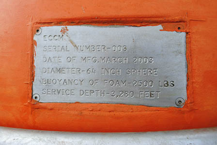
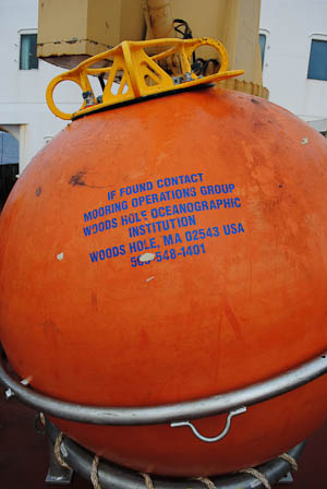
Alex KainSeptember 30, 2009Unlike drifting buoys and Ice-Tethered Profilers, the most recently recovered mooring, Beaufort Gyre Observing System-A (BGOS-A), latches to an anchor on the ocean floor and remains stationary throughout the year. A 64 inch diameter orange float provides 2,500 pounds of buoyancy, making its vertical line taut and straight. The top buoy stays 46 meters below the surface and ice cover of the Beaufort Sea.
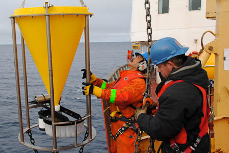
Profiling instruments are attached at various points along the length of the line. A McLane Moored Profiler collects temperature, salinity, and velocity profiles between 50 and 2,050 meters throughout the year. Additionally, three instruments called sediment traps fasten to the line at 2,050, 3,100, and 3,750 meters. Profiling instruments are attached at various points along the length of the line. Sediment traps collect organic material that falls through the water, typically materials like silica and carbonate that come from the shells and skeletons of phyto- and zooplankton. The traps are designed with two principal components: a giant funnel that directs falling sediment into a small area, and a carousel of test bottles that collects the samples.
By being spread at distances from the surface of the Beaufort Sea, sediment traps collect organic matter from depths that correspond to various underwater currents, each of which has unique characteristics. Ocean water doesn't exactly blend and dissolve into one aquatic mass. It slides around in layers of different temperature and salinity. Water is layered throughout the Beaufort Sea in surprising ways. A common misconception is that water temperature varies directly with depth; that is, the deeper you go in the Arctic, the colder you get. This is not entirely the case. The first 250 meters of the Beaufort Sea are cold. Really cold. Frigid water from the North Pacific interacts with sea ice to produce water that hovers around -1.5 degrees Celsius in a chilly layer known as the halocline. Beneath the bottom edge of the halocline later, however, it's a different story. Warmer, saltier water from the North Atlantic occupies a zone from about 250 to 800 meters. This water, brought to the Beaufort Sea by currents in the Barents Sea and the Fram Strait, reaches a sizzling 1.5 degrees Celsius at its warmest. Beneath that, the water remains colder than the Atlantic layer. Each current of water comes with a unique distribution of plankton species and detritus. By collecting the organic samples from various depths at designated time periods, the organic matter reveals at what depths and temperatures the organisms live throughout the year. Researchers can correlate the sediment with the water from which it comes, helping to track the mass movement of currents throughout the earth. More importantly, sediment samples help explain ocean conditions throughout geologic time. Sediment is the link between the surface and the bottom of the ocean. As the conditions of the planet changed throughout millions of years, characteristics of the sediment covering the ocean bottom changed as well. The different sediments accumulated on the ocean floor, forming distinct layers. Each of these layers corresponds to an ambient ocean environment with specific temperatures, salinities, and concentrations of minerals. Understanding the relationship between the different sediments in these layers and their corresponding ocean conditions allows scientists to work backwards and see how the oceans evolved over time. As WHOI's Rick Krishfield described, sediment acts like the "tree rings of the ocean" because of its ability to uncover the biogeochemical history of the world's oceans. WHOI technicians will deploy two more moorings throughout the expedition, each of which will provide invaluable data that will illuminate the state of the world's oceans, both ancient and contemporary. All text and photos property of Alex Kain. Last updated: October 7, 2019 | |||||||||||||||||||
Copyright ©2007 Woods Hole Oceanographic Institution, All Rights Reserved, Privacy Policy. | |||||||||||||||||||