Alex KainOctober 11, 2009Ask an Arctic oceanographer about their research, and they'll probably mention projects involving ice and water located in the surface layers of the ocean. These top regions sustain a unique ecosystem, exhibit complex currents, and offer a chance to study the interaction between the atmosphere and the sea. Although surface water studies dominate oceanographic discourse, the layers closer to the seafloor than the surface hold their own mysteries. Below 2,500 meters (8,200 feet) of depth, the deepest regions of the Arctic Ocean contain a separate world of ocean dynamics, most of which is just beginning to be investigated and understood. "We're always thinking about shallow waters in the Arctic, but we don't pay much attention to what's happening in the deepest regions," says Mary-Louise Timmermans, an Arctic oceanographer from Yale University. Deep-water data collections in the Beaufort Sea occur via rosette casts, which collect samples for chemical analysis, and through moorings, vertical lines anchored to the bottom of the sea and held taut by buoys that rise 50 meters (160 feet) below the ocean's surface. Along the line, probes monitor ocean conditions in surface, intermediate, and deep layers of water.
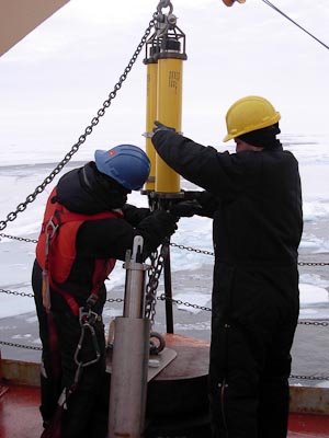
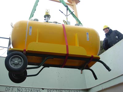
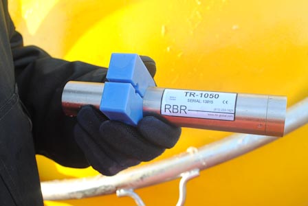
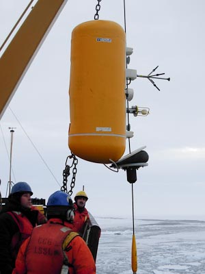
Today on the Louis, a team of WHOI scientists and Coast Guard technicians deployed Mooring D at 140° W, 70° N, about eighty nautical miles off the coast of Alaska. The profilers on the mooring include a current meter, ice movement monitors, a sediment trap (a funnel that collects organic matter falling through the ocean), and a McLane Moored Profiler (MMP), which runs up and down the line between 50 and 2,050 meters (164 to 6,730 feet) of depth to collect salinity, temperature, and depth readings. The mooring also holds a series of thermistors, devices that monitor temperature, in a deep region of interest, between 2,350 and 2,850 meters (7,710 and 9,350 feet). The Beaufort Sea presents a unique area of ocean activity. Its depths contain the saltiest water in the Arctic Ocean. Moreover, scientists believe that these depths have been isolated from shallower waters for at least the past 500 years. The water's isolation makes it less subject to seasonal and interannual variability. The deep waters of the Beaufort Sea "may prove to be valuable markers of past climate states and future climate changes," Timmermans says.
Studies using Mooring D data will aim to explore how the salty water got there and whether past climate shifts ended similar influxes of salty water into other Arctic zones. "Understanding the present day properties and dynamics of the deep water may give us insight into past Arctic climate systems," Timmermans says. Observations of the deepest Arctic waters began in the mid-1990s when Fisheries and Oceans Canada (DFO) oceanographer Eddy Carmack performed deep CTD casts and discovered that below 2,500 meters (8,200 feet), distinct layers of water varied in temperature by a few thousandths of a degree. Below the layers, from about 2,600 to the seafloor at 3,500 meters (8,500-11,500 feet), the bottom water was entirely homogenous in temperature and salinity. In 2002, Timmermans and Humfrey Melling, a collaborator from DFO, deployed a series of thermistors at a site near Mooring D. Their data provided surprising results. Where the team had expected to find a quiescent (dormant) water basin, they found underwater waves, or "excursions," horizontal sheets of water that rise and fall tens of meters without mixing. Where they had expected to find static aquatic strata, they ended up finding saltwater ribbons that danced and flowed. Timmermans will continue to study these underwater waves that appear to propagate in the bottom water. Thermistors attached at ten-meter intervals between 2,500 and 2,610 meters (8,200 to 8,500 feet) of depth, exactly in the excursion region, aim to obtain precise measurements of this dynamic zone. "The mooring D data will help us quantify the forcing mechanisms for these waves, along with the circulation, dynamics, and mixing in the deep Arctic Ocean," she says. As for future deep-water studies, Timmermans will continue to monitor the Beaufort Sea, but she also has her eyes set on the warmer waters of the Mediterranean, which exhibit similar ocean dynamics. The seas there are "equally fascinating," she says. "And also, an expedition to the Med wouldn't be so bad." All text property of Alex Kain. All photos by Rick Krishfield. Last updated: October 7, 2019 | |||||||||||||||||||||||
Copyright ©2007 Woods Hole Oceanographic Institution, All Rights Reserved, Privacy Policy. | |||||||||||||||||||||||