Please note: You are viewing
the unstyled version of this website. Either your browser does not support CSS
(cascading style sheets) or it has been disabled. Skip
navigation.


Chris LinderAugust 28, 2005
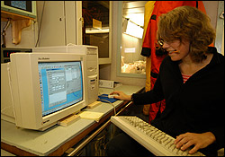
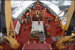
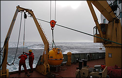
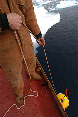
For once, my schedule prediction from the night before is actually correct--we were at the Mooring D deployment site right on schedule this morning. Mooring D is the fourth deep Beaufort Gyre Observing System mooring. The four moorings form the corners of a box, and this one is in the southeast corner. This is a new mooring starting this year--for the past two years, we have only had A, B, and C. After the first expedition in 2003, the CTD survey revealed that the Beaufort Gyre's fresh water mass, normally centered near Mooring B, had shifted its position substantially to the southeast. Principal Investigator Andrey Proshutinsky responded to this new information by adding Mooring D to the Observing System. With this new position, we have a very complete picture of how the temperature, salinity, currents, and ice is changing across the Beaufort Gyre. Mooring D is also unique in that it is the only mooring containing an upward-looking Acoustic Doppler Current Profiler (ADCP). Mounted in a strong bracket on the top sphere, this instrument uses pulses of sound to measure the currents and ice drift above the mooring. The sound bounces off tiny particles in the water to determine the currents, and bounces off the bottom of the ice to determine the ice motion. Although it would have been best to have an ADCP on each mooring, financial constraints have limited us to only one. Since this was a new mooring site, we needed to first complete a depth survey before deploying. This involved steaming in a star pattern and checking our Knudsen depth finder to find the water depth. Our mooring lines are precut, so we don't have a lot of leeway in picking a location--the depth has to be close. If the spot is too shallow, the top float will be too high and it could be impacted by the ice. If the spot is too deep, the ADCP might not be able to measure all the way up to the ice. We also needed to think about timing. Since a mooring deployment takes up to five hours and the ship is drifting the whole time, we needed to figure out the set and drift (direction and speed of motion) of the ship before starting as well. With that information, the mates can position the ship in such a way that we drift to the precise location at the end of the deployment, and then drop the mooring. At least, that's the theory. Expectation lived up to theory today, though--we appear to have finally broken the curse of the Beaufort Triangle. Aside from the snow flurries, the weather was warm and calm and the ice was light. With minimal use of the bubbler system, a large ice-free pond was created for the gear going over the side. The mooring went smoothly, and the depth was perfect when Kris Newhall peered down at the top float with the release in his hands. With a firm pull on the cord, the yellow float sank into the clear, dark blue water. BGOS complete! Only three working days (and nights) remain for the expedition. We have to redeploy one last mooring (the shallow water CABOS mooring for our colleagues from Fairbanks, Alaska) and finish our CTD sampling. All the while we will be cruising south and east to our disembarkation point in Kugluktuk, Nunavut, Canada. Last updated: October 7, 2019 | ||||||||||||||||||||||
Copyright ©2007 Woods Hole Oceanographic Institution, All Rights Reserved, Privacy Policy. | ||||||||||||||||||||||